IMAGES TAKEN NEAR TO
Denton Street, CARLISLE, CA2 5EQ
Introduction
This page details the photographs taken nearby to Denton Street, CA2 5EQ by members of the Geograph project.
The Geograph project started in 2005 with the aim of publishing, organising and preserving representative images for every square kilometre of Great Britain, Ireland and the Isle of Man.

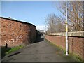
There are currently over 7.5m images from over14,400 individuals and you can help contribute to the project by visiting https://www.geograph.org.uk
Image Map
Images are licensed for reuse under creativecommons.org/licenses/by-sa/2.0
Notes
- Clicking on the map will re-center to the selected point.
- The higher the marker number, the further away the image location is from the centre of the postcode.
Image Listing (217 Images Found)
Images are licensed for reuse under creativecommons.org/licenses/by-sa/2.0
Image
Details
Distance
1
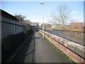
The Cumbria Way, Denton Holme
The Cumbria Way long distance path follows the Caldew Cycleway along the back of the River Caldew flood defence wall at Denton Holme (next photograph Image). This section of the Caldew Cycleway is also known as the Caldew Riverside Trail.
Denton Holme can also be spelled as Dentonholme; the various railway companies that maintained facilities in this part of Carlisle almost exclusively used Dentonholme, Denton Holme is more common elsewhere.
Image: © Adrian Taylor
Taken: 11 Mar 2019
0.03 miles
2
The Cumbria Way, Denton Holme
The Cumbria Way long distance path follows the Caldew Cycleway along the back of the River Caldew flood defence wall at Denton Holme (next photograph Image). This section of the Caldew Cycleway is also known as the Caldew Riverside Trail.
Denton Holme can also be spelled as Dentonholme; the various railway companies that maintained facilities in this part of Carlisle almost exclusively used Dentonholme, Denton Holme is more common elsewhere.
Image: © Adrian Taylor
Taken: 28 Sep 2013
0.03 miles
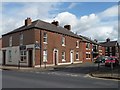
3
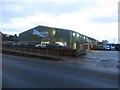
Retail showroom, Denton Street, Carlisle
A retail showroom belonging to a seller of timber products, on Denton Street.
Image: © Graham Robson
Taken: 30 Oct 2014
0.04 miles
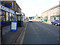
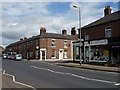
4
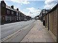
Bus stop on Denton Street, Carlisle
Looking south towards the raised pavement, from the junction with Thomas Street.
Image: © Christine Johnstone
Taken: 11 Apr 2014
0.05 miles
5
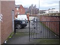
Access control on the Caldew Cycleway
Hopefully sufficient to deter motor bikes! Thomas Street is to the left. On the right is a flood wall to protect the housing from flooding by the River Caldew.
Image: © Oliver Dixon
Taken: 25 Jan 2016
0.05 miles
6
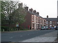
Lime Street, Carlisle
Numbers 17 to 33, as the rest have been demolished.
Image: © Stuart Irving
Taken: 6 May 2008
0.05 miles
7
New and old homes on Thomas Street, Carlisle
Looking east from Denton Street.
Image: © Christine Johnstone
Taken: 11 Apr 2014
0.05 miles
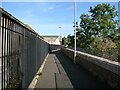
9
The Cumbria Way, Metcalfe Street
Passing beside the curved wall of a garage at the end of Metcalfe Street, The Cumbria Way long distance path follows the Caldew Cycleway along the back of the River Caldew flood defence wall at Denton Holme (next photograph Image). This section of the Caldew Cycleway is also known as the Caldew Riverside Trail.
Image: © Adrian Taylor
Taken: 11 Mar 2019
0.07 miles
10
Junction of Metcalfe and Denton Streets, Carlisle
Wonderful chequerboard brickwork catching the sun.
Image: © Christine Johnstone
Taken: 11 Apr 2014
0.07 miles