IMAGES TAKEN NEAR TO
Viaduct Estate Road, CARLISLE, CA2 5BN
Introduction
This page details the photographs taken nearby to Viaduct Estate Road, CA2 5BN by members of the Geograph project.
The Geograph project started in 2005 with the aim of publishing, organising and preserving representative images for every square kilometre of Great Britain, Ireland and the Isle of Man.

There are currently over 7.5m images from over14,400 individuals and you can help contribute to the project by visiting https://www.geograph.org.uk
Image Map
Images are licensed for reuse under creativecommons.org/licenses/by-sa/2.0
Notes
- Clicking on the map will re-center to the selected point.
- The higher the marker number, the further away the image location is from the centre of the postcode.
Image Listing (1289 Images Found)
Images are licensed for reuse under creativecommons.org/licenses/by-sa/2.0
Image
Details
Distance
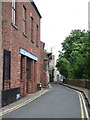
1
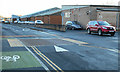
Viaduct Estate Road
Eden Bridge Club is nearest the camera.
Image: © Thomas Nugent
Taken: 3 Jan 2015
0.00 miles
2
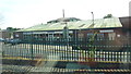
Gemini Tile Showroom, Carlisle
Taken from a southbound train on the West Coast Main Line.
Image: © Richard Cooke
Taken: 17 Jul 2013
0.02 miles
4
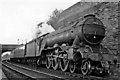
Up 'Thames-Clyde Express' entering Carlisle
View northward, on the WCML out of Carlisle, with the main (ex-Caledonian) line curving below the West Walls and under the Viaduct Bridge. By 1960 the 'Thames-Clyde Express' (London St Pancras - Leeds - Glasgow St Enoch) was being hauled for a year or two on the Glasgow - Leeds stretch by ex-LNER A3 Pacifics transferred to Leeds (Holbeck) Depot: here it is No. 60088 'Book Law'.
Image: © Ben Brooksbank
Taken: 12 Aug 1960
0.03 miles
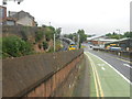
5
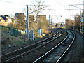
West Coast Main Line at Carlisle
North of Carlisle station, at Viaduct Estate Road.
Image: © Thomas Nugent
Taken: 3 Jan 2015
0.03 miles
6
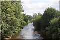
River in the city
Carlisle's 'other' river, the Caldew (https://en.wikipedia.org/wiki/River_Caldew ) has its source near Skiddaw mountain in the lake district and its confluence with the River Eden about 1 km behind the photographer.
Image: © Bill Harrison
Taken: 17 Aug 2019
0.03 miles
7
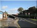
Viaduct Estate Road
This part of the Viaduct Estate Road is the route of The Cumbria Way, leading up the ramp beside the West Coast Main Line railway (next photograph Image).
The bridge in the left background was provided for the Carlisle Goods Lines and railway tracks leading into the Viaduct Goods Yard.
Some commercial premises still remain on the Viaduct Estate, but it is beside the River Caldew and has been subjected to several flooding events; consequently much of the former railway goods yard is now used for car parking.
Image: © Adrian Taylor
Taken: 11 May 2015
0.03 miles
8
West Walls
There is an OS benchmark Image on the wall near the right hand edge of the image
Image: © Roger Templeman
Taken: 16 Jun 2012
0.04 miles
10
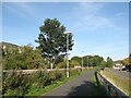
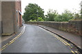
The Caldew Cycleway, Viaduct Estate
The River Caldew flows behind the flood defence wall on the left.
The flood defence wall was constructed after the 2009 floods to protect commercial premises on the Viaduct Estate, but cost cutting to the original design specification rendered the flood defences ineffective and the businesses on the Viaduct Estate were flooded again in 2015.
The Caldew Cycleway is the route of The Cumbria Way long distance path (next photograph Image).
Image: © Adrian Taylor
Taken: 28 Sep 2013
0.04 miles