IMAGES TAKEN NEAR TO
Long Island Park, CARLISLE, CA2 5AS
Introduction
This page details the photographs taken nearby to Long Island Park, CA2 5AS by members of the Geograph project.
The Geograph project started in 2005 with the aim of publishing, organising and preserving representative images for every square kilometre of Great Britain, Ireland and the Isle of Man.

There are currently over 7.5m images from over14,400 individuals and you can help contribute to the project by visiting https://www.geograph.org.uk
Image Map
Images are licensed for reuse under creativecommons.org/licenses/by-sa/2.0
Notes
- Clicking on the map will re-center to the selected point.
- The higher the marker number, the further away the image location is from the centre of the postcode.
Image Listing (566 Images Found)
Images are licensed for reuse under creativecommons.org/licenses/by-sa/2.0
Image
Details
Distance
1
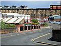
Rome Street, Carlisle
Seen from the railway bridge; beyond the wall is Citadel station.
Image: © Stephen McKay
Taken: 20 Jun 2008
0.04 miles
2
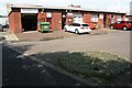
Industrial units on NW side of Rome Street
Ordnance Survey records indicate that a benchmark levelled at 16.357m above Newlyn Datum was verified in 1972 on No. 8 Rome Street previously at this location
Image: © Roger Templeman
Taken: 19 Aug 2019
0.04 miles
3
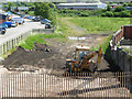
Rome Street Junction
Seen from the Rome Street Bridge, this was once the site of Rome Street Junction on the Carlisle avoiding lines, which gave freight trains an alternative route missing Citadel station, part of the complex railway layout around Carlisle. See http://www.cumbria-railways.co.uk/bog_junction_carlisle.html for details of the history of this railway. Network Rail has recently raised the possibility of reinstating this route to relieve congestion in the station.
Image: © Stephen McKay
Taken: 20 Jun 2008
0.06 miles
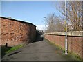
4
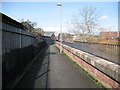
The Cumbria Way, Denton Holme
The Cumbria Way long distance path follows the Caldew Cycleway along the back of the River Caldew flood defence wall at Denton Holme (next photograph Image). This section of the Caldew Cycleway is also known as the Caldew Riverside Trail.
Denton Holme can also be spelled as Dentonholme; the various railway companies that maintained facilities in this part of Carlisle almost exclusively used Dentonholme, Denton Holme is more common elsewhere.
Image: © Adrian Taylor
Taken: 11 Mar 2019
0.07 miles
5
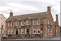
Former "Cumberland Wrestlers" - June 2017
The original "Cumberland Wrestlers" was built on this site 1875/76 and came under State Management control on 23 August 1916. It was demolished in 1937 and replaced by this Harry Redfern designed building, which opened on 3 October 1938. Sold to Scottish & Newcastle on 16 April 1973, the pub closed in 2004. With permission from the staff, an inspection of the ground floor revealed no trace of any pub fittings.
Photograph is for record only - I have no connection with any business seen in this view and cannot advise on their products or services.
Image: © The Carlisle Kid
Taken: 14 Jun 2017
0.07 miles
6
The Cumbria Way, Denton Holme
The Cumbria Way long distance path follows the Caldew Cycleway along the back of the River Caldew flood defence wall at Denton Holme (next photograph Image). This section of the Caldew Cycleway is also known as the Caldew Riverside Trail.
Denton Holme can also be spelled as Dentonholme; the various railway companies that maintained facilities in this part of Carlisle almost exclusively used Dentonholme, Denton Holme is more common elsewhere.
Image: © Adrian Taylor
Taken: 28 Sep 2013
0.07 miles
7

St Stephen's Street, St Stephen's Day
View towards the top of James Street, with Carlisle Cathedral in the distance.
Image: © Rose and Trev Clough
Taken: 26 Dec 2013
0.07 miles
8
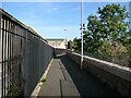
Access control on the Caldew Cycleway
Hopefully sufficient to deter motor bikes! Thomas Street is to the left. On the right is a flood wall to protect the housing from flooding by the River Caldew.
Image: © Oliver Dixon
Taken: 25 Jan 2016
0.08 miles
9
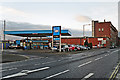
James Street Service Station
Petrol filling station with a convenience store and used car sales.
The business is on the site of the former St Stephen's Church, a substantial Gothic-style building consecrated in 1865 and demolished 99 years later (more information at Carlisle Encyclopaedia http://www.carlisleshistory.co.uk/page42.htm ) . A photo of the church can be seen at Cumbria Image Bank https://www.hpacde.org.uk/cumbria/jpgh/ct01708.jpg (C.I.B. main page : http://cumbriaimagebank.org.uk ).
Image: © Rose and Trev Clough
Taken: 26 Dec 2013
0.08 miles
10
The Cumbria Way, Metcalfe Street
Passing beside the curved wall of a garage at the end of Metcalfe Street, The Cumbria Way long distance path follows the Caldew Cycleway along the back of the River Caldew flood defence wall at Denton Holme (next photograph Image). This section of the Caldew Cycleway is also known as the Caldew Riverside Trail.
Image: © Adrian Taylor
Taken: 11 Mar 2019
0.09 miles