IMAGES TAKEN NEAR TO
South John Street, CARLISLE, CA2 5AJ
Introduction
This page details the photographs taken nearby to South John Street, CA2 5AJ by members of the Geograph project.
The Geograph project started in 2005 with the aim of publishing, organising and preserving representative images for every square kilometre of Great Britain, Ireland and the Isle of Man.

There are currently over 7.5m images from over14,400 individuals and you can help contribute to the project by visiting https://www.geograph.org.uk
Image Map
Images are licensed for reuse under creativecommons.org/licenses/by-sa/2.0
Notes
- Clicking on the map will re-center to the selected point.
- The higher the marker number, the further away the image location is from the centre of the postcode.
Image Listing (654 Images Found)
Images are licensed for reuse under creativecommons.org/licenses/by-sa/2.0
Image
Details
Distance
1
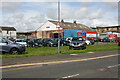
Border City Autos on NW side of Crown Street
Ordnance Survey records indicate that a benchmark levelled at 17.569m above Newlyn Datum was verified in 1972 on Building 26 previously at this location
Image: © Roger Templeman
Taken: 19 Aug 2019
0.02 miles
2
Site of "Oddfellows Inn" - June 2017
Situated at the junction of Crown Street and Currock Street, the Oddfellows Inn dated from mid to late 19th Century (possibly 1855) and may have been owned by the Maryport Brewery Co. It was deemed unsuitable by the State Management Scheme and closed on 11 October 1916. Date of demolition has not yet been traced.
Image: © The Carlisle Kid
Taken: 14 Jun 2017
0.03 miles
3
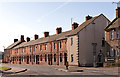
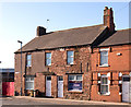
Currock Street, Carlisle - March 2018
Only the south side survives of Victorian Currock Street - but it gives some indication of the density of pubs in Carlisle in 1916. To the right can be seen the former "Cumberland Wrestlers" (see: Image] ) while at far left is the long closed "Moulders Arms" (see: Image] ). Behind me would have been the "Oddfellows Inn" (see: Image] ) while a few minutes walk north from the "Moulders Arms" was the "Goliah/Goliath Inn" (see: Image] ).
Image: © The Carlisle Kid
Taken: 26 Mar 2018
0.03 miles
4
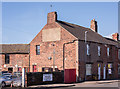
Former "Moulders Arms", Currock Street - March 2018
A former pub which appears on no OS Map, the "Moulders Arms" probably dates from circa 1850. It was closed by the State Management Scheme on 20 September 1916 and has been a private house for the last 102 years.
Apparently, until recent times, the name could still just be seen on the end wall.
Image: © The Carlisle Kid
Taken: 9 Mar 2018
0.04 miles
5
Former "Moulders Arms", Currock Street - March 2018 (2)
For information on this building, see: Image] .
Image: © The Carlisle Kid
Taken: 26 Mar 2018
0.04 miles
6
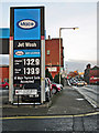
Fireplace Showroom, Carlisle
Crown Fireplaces, Crown Street, Carlisle.
Image: © Wayland Smith
Taken: 25 May 2013
0.04 miles
7
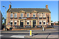
Former "Cumberland Wrestlers" - June 2017
The original "Cumberland Wrestlers" was built on this site 1875/76 and came under State Management control on 23 August 1916. It was demolished in 1937 and replaced by this Harry Redfern designed building, which opened on 3 October 1938. Sold to Scottish & Newcastle on 16 April 1973, the pub closed in 2004. With permission from the staff, an inspection of the ground floor revealed no trace of any pub fittings.
Photograph is for record only - I have no connection with any business seen in this view and cannot advise on their products or services.
Image: © The Carlisle Kid
Taken: 14 Jun 2017
0.05 miles
8
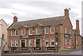
Site of "Goliah/Goliath Inn" - March 2018
Situated on the corner of Crown Street and Robert Street (where the cars are parked), the "Goliah Inn" dated from 1842-48 and took its name from a locomotive on the Newcastle & Carlisle Railway. Period photographs show the name clearly as "Goliah Inn", but it is not known if this apparent spelling error simply reflected the name applied to the locomotive. Period photographs also show the name was eventually changed to "Goliath Inn".
A 1901/02 view of this pub may be found: http://closedpubs.co.uk/cumberland/carlisle_goliah.html
The "Goliath Inn" was acquired by the State Management Scheme on 29 August 1916 and was converted to a food tavern, reopening on 18 June 1917. However, it closed in 1938 due to the opening of the nearby Redfern designed "Cumberland Wrestlers" (see: Image] ). Date of demolition has not been found, but it appears to have survived until at least 1991.
Photograph is for record only – I have no connection with any business seen in this view and cannot advise on their products or services.
Image: © The Carlisle Kid
Taken: 9 Mar 2018
0.05 miles
9
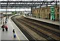
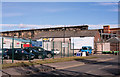
Carlisle Citadel Station
Looking south from the overbridge connecting Platform 1 and Platform 3.
Image: © Richard Sutcliffe
Taken: 9 May 2019
0.06 miles
10
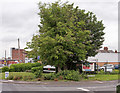
St Stephen's Street, St Stephen's Day
View towards the top of James Street, with Carlisle Cathedral in the distance.
Image: © Rose and Trev Clough
Taken: 26 Dec 2013
0.08 miles