IMAGES TAKEN NEAR TO
Millholme Avenue, CARLISLE, CA2 4DW
Introduction
This page details the photographs taken nearby to Millholme Avenue, CA2 4DW by members of the Geograph project.
The Geograph project started in 2005 with the aim of publishing, organising and preserving representative images for every square kilometre of Great Britain, Ireland and the Isle of Man.

There are currently over 7.5m images from over14,400 individuals and you can help contribute to the project by visiting https://www.geograph.org.uk
Image Map
Images are licensed for reuse under creativecommons.org/licenses/by-sa/2.0
Notes
- Clicking on the map will re-center to the selected point.
- The higher the marker number, the further away the image location is from the centre of the postcode.
Image Listing (41 Images Found)
Images are licensed for reuse under creativecommons.org/licenses/by-sa/2.0
Image
Details
Distance
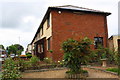
1
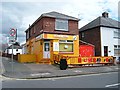
Chinese Takeaway
This brightly coloured shop is at the corner of Millholme Avenue and Blackwell Road. There used to be more decoration on the fence, but it has taken a bit of a kicking.
Image: © Rose and Trev Clough
Taken: 11 Jun 2008
0.06 miles
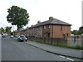
4
#40 Ridley Road
The house has been extended on its east face obliterating an Ordnance Survey benchmark described as 'CUT MARK NO40 RIDLEY RD E FACE SE ANG 35.646m above Newlyn Datum'
Image: © Roger Templeman
Taken: 20 May 2017
0.07 miles
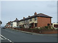
5
#241 Blackwell Road at Ridley Road junction
There is an OS benchmark Image picked out in white on the facing side of the house near its front corner
Image: © Roger Templeman
Taken: 20 May 2017
0.07 miles
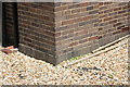
6
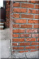
Benchmark on Ridley Road face of #241 Blackwell Road
Ordnance Survey cut mark benchmark described on the Bench Mark Database at http://www.bench-marks.org.uk/bm38668
Image: © Roger Templeman
Taken: 26 Jun 2011
0.07 miles
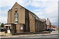
8
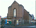
Currock Methodist Church being converted to flats
The church closed in 2006 - a dwindling congregation had made it unviable. The redevelopment, containing 14 flats, is now called Methodist Court.
This part of the building dates from the 1930s. It was an extension to the original church built in 1908, which then became the church hall.
For more historical information, see http://www.mywesleyanmethodists.org.uk/page/carlisle_currock_road_wm_chapel_cumberland .
Image: © Rose and Trev Clough
Taken: 28 Dec 2007
0.09 miles
9
Former Baptist Church from Boston Avenue
View across Blackwell Road
Image: © Roger Templeman
Taken: 26 Jun 2011
0.09 miles
10
Benchmark on former Baptist Church, Currock Road
Ordnance Survey cut mark benchmark described on the Bench Mark Database at http://www.bench-marks.org.uk/bm38720
Image: © Roger Templeman
Taken: 26 Jun 2011
0.09 miles