IMAGES TAKEN NEAR TO
Hartley, KIRKBY STEPHEN, CA17 4JH
Introduction
This page details the photographs taken nearby to CA17 4JH by members of the Geograph project.
The Geograph project started in 2005 with the aim of publishing, organising and preserving representative images for every square kilometre of Great Britain, Ireland and the Isle of Man.

There are currently over 7.5m images from over14,400 individuals and you can help contribute to the project by visiting https://www.geograph.org.uk
Image Map
Images are licensed for reuse under creativecommons.org/licenses/by-sa/2.0
Notes
- Clicking on the map will re-center to the selected point.
- The higher the marker number, the further away the image location is from the centre of the postcode.
Image Listing (21 Images Found)
Images are licensed for reuse under creativecommons.org/licenses/by-sa/2.0
Image
Details
Distance
1
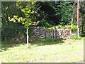
Village pinfold, Hartley
A small stone enclosure in the village street, shown on early edition OS maps as a 'pound' or pinfold, put here to confine stray animals.
Image: © Gordon Hatton
Taken: 24 Aug 2014
0.04 miles
2
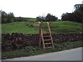
Brand new
Stile for the start of the footpath to Ponder Hill
Image: © Alexander P Kapp
Taken: 25 Oct 2006
0.06 miles
4
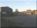
Hartley Fold
Light industrial units.
Image: © Stephen Craven
Taken: 25 Jun 2009
0.08 miles
5
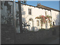
Hartley House
The property is named as if the principal building in the village, yet appears from the outside not to be special in any way.
Probably not many houses in Cumbria can boast monkey-puzzle trees in the garden. The lower branches of a mature one can just be seen at the top of the photo along with a sapling next to it.
Image: © Stephen Craven
Taken: 25 Jun 2009
0.13 miles
6
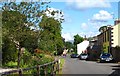
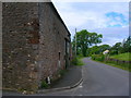
Village street, Hartley
Quiet village on a dead end road to the east of Kirkby Stephen.
Image: © Gordon Hatton
Taken: 24 Aug 2014
0.13 miles
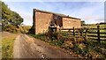
7
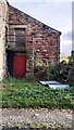
Barn on SE side of Common Lane
There is an Ordnance Survey benchmark Image on the right hand corner of the barn beside the downpipe
Image: © Roger Templeman
Taken: 25 Oct 2022
0.14 miles
8
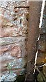
Benchmark on barn on SE side of Common Lane
Ordnance Survey cut mark benchmark levelled at 191.478m above Newlyn Datum verified 1954
Image: © Roger Templeman
Taken: 25 Oct 2022
0.14 miles
9
Common Lane - a track towards Whingill
Image: © Roger Templeman
Taken: 25 Oct 2022
0.15 miles
10
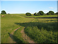
Track through a rural conservation area
The field through which this track runs is the John Sturtt Conservation Area, according to a sign on the gate. The track gives public access to the former railway track nearby Image
Image: © Stephen Craven
Taken: 25 Jun 2009
0.17 miles