IMAGES TAKEN NEAR TO
Smardale, KIRKBY STEPHEN, CA17 4HG
Introduction
This page details the photographs taken nearby to CA17 4HG by members of the Geograph project.
The Geograph project started in 2005 with the aim of publishing, organising and preserving representative images for every square kilometre of Great Britain, Ireland and the Isle of Man.

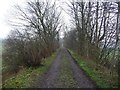
There are currently over 7.5m images from over14,400 individuals and you can help contribute to the project by visiting https://www.geograph.org.uk
Image Map
Images are licensed for reuse under creativecommons.org/licenses/by-sa/2.0
Notes
- Clicking on the map will re-center to the selected point.
- The higher the marker number, the further away the image location is from the centre of the postcode.
Image Listing (45 Images Found)
Images are licensed for reuse under creativecommons.org/licenses/by-sa/2.0
Image
Details
Distance
1
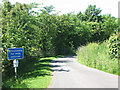
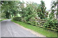
Beck Lane, Smardale
The reason why the lane is unsuitable for wide vehicles (according to the sign) is not stated but probably refers to the ford at the bottom of the hill Image
Image: © Stephen Craven
Taken: 23 Jun 2009
0.07 miles
2
Smardale railway station (site), Cumbria
Opened in 1861 by the South Durham and Lancashire Union Railway (later part of the North Eastern railway) on the line from Barnard Castle to Tebay over Stainmore summit, this station closed in 1952. View west towards Ravenstonedale and Tebay.
Image: © Nigel Thompson
Taken: 25 Feb 2012
0.07 miles
3
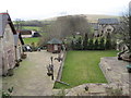
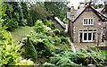
The former Smardale Station
Now a private residence. Smardale Hall is behind.
Image: © Bill Boaden
Taken: 24 Jul 2010
0.07 miles
4
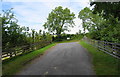
The former bridge over the railway
At the far side is the choice of going to Crosby Garrett or Smardale Mill.
Image: © Bill Boaden
Taken: 24 Jul 2010
0.08 miles
5
Former railway, now a footpath
The former Kirkby Stephen - Tebay line is now a footpath within a Cumbria Wildlife Trust site. For more information see http://www.nvt.org.uk .
Image: © Christine Johnstone
Taken: 29 Mar 2011
0.08 miles
6
Smardale Station House
The embankment to the left of the house supports a road which was previously a bridge over the dismantled railway. The bridge had an Ordnance Survey benchmark levelled at 222.687m above Newlyn Datum verified in 1970
Image: © Luke Shaw
Taken: 31 Aug 2019
0.09 miles
7
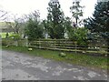
Embankment in place of School Lane bridge
School Lane, which runs just behind the fence visible in the photo, takes its name from a former village school Image in NY7407. It would have crossed the railway line on a bridge at this point, but at some time since the railway closed in the 1960s, the bridge has been demolished and replaced by an embankment.
Image: © Stephen Craven
Taken: 23 Jun 2009
0.09 miles
8
School Lane where it crosses dismantled railway trackbed
The original stone bridge parapet now replaced by a fence and Smardale Station which it overlooked long gone
Image: © Roger Templeman
Taken: 17 Sep 2014
0.09 miles
9
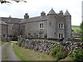
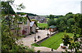
Smardale Hall
A fortified manor house dating from the 15th and 16th centuries. http://www.visitcumbria.com/pen/smardalehall.htm
Image: © David McMumm
Taken: 21 Jun 2010
0.09 miles
10
Roadside fence, Smardale Station
With the former Smardale Station building in the background, the roadside fence marks the approximate position of the parapet of a demolished and filled in railway bridge. There was an Ordnance Survey benchmark on the parapet somewhere near the position of the left hand stone; it marked a height of 222.6869m above sea level (Ordnance Datum Newlyn) and was last verified in 1970. Note the unofficial 'No Parking' sign on the fence; this is a popular starting point for walkers following the railway path to Smardale Gill.
Image: © Adrian Taylor
Taken: 27 Nov 2020
0.09 miles