IMAGES TAKEN NEAR TO
Furnace Road, MARYPORT, CA15 6DG
Introduction
This page details the photographs taken nearby to Furnace Road, CA15 6DG by members of the Geograph project.
The Geograph project started in 2005 with the aim of publishing, organising and preserving representative images for every square kilometre of Great Britain, Ireland and the Isle of Man.

There are currently over 7.5m images from over14,400 individuals and you can help contribute to the project by visiting https://www.geograph.org.uk
Image Map
Images are licensed for reuse under creativecommons.org/licenses/by-sa/2.0
Notes
- Clicking on the map will re-center to the selected point.
- The higher the marker number, the further away the image location is from the centre of the postcode.
Image Listing (238 Images Found)
Images are licensed for reuse under creativecommons.org/licenses/by-sa/2.0
Image
Details
Distance
1
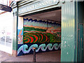
Mosaic, Mill Race Lonning, Maryport
Mosaic depicting the history of Maryport.
Image: © Jim Osley
Taken: 28 Jun 2013
0.03 miles
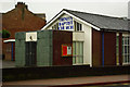
3
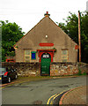
Gospel Hall, Furnace Road, Maryport (1861)
Image: © Jim Osley
Taken: 28 Jun 2013
0.03 miles
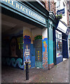
4
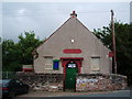
Furness Road, Gospel Hall, Maryport
Image: © Alexander P Kapp
Taken: 5 Aug 2007
0.04 miles
5
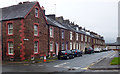
Terraced houses, Mill Street, Maryport (1887)
Image: © Jim Osley
Taken: 28 Jun 2013
0.05 miles
6
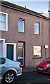
Site of "Artillery Arms" pub, Maryport - October 2017
The "Artillery Arms" appears as an Inn on the 1866 OS Map and was acquired by the State Management Scheme in November 1918. As it is not shown on the 1925 OS Map, it was probably closed by the scheme not long after purchase.
This house seems to be on the approximate site as shown in: https://pubshistory.com/Cumberland/Maryport/ArtilleryArms.shtml , but is obviously modern with no clear trace of the original building.
Private dwelling with no public access.
Image: © The Carlisle Kid
Taken: 27 Oct 2017
0.06 miles
7
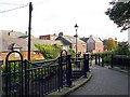
Mill Race Lonning
Footpath to Mill Street Car Park, which starts from a passage in Senhouse Street http://www.geograph.org.uk/photo/744201 .
There is no sign of any water - the Mill Race was filled in during the late 19th century http://www.allerdale.gov.uk/downloads/Maryport_Conservation_Area_Appraisal.pdf .
Houses at the centre of the picture are in Mill Street North.
Image: © Rose and Trev Clough
Taken: 30 Sep 2010
0.06 miles
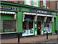
8
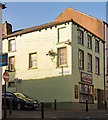
Former "Shakespear" pub, Maryport - October 2017
First mentioned in the Post Office Directory of 1873, the pub does not appear on the 1865 OS Map which suggests it opened between these dates. Acquired by the State Management Scheme in November 1918, no record has yet been found of sale - although it is marked on the 1970 OS Map. This - as I have discovered - means little!
Premises are now "Mr Simms Olde Sweet Shoppe" - with whom I have no connection and, while tempted, cannot advise on its products or services.
Image: © The Carlisle Kid
Taken: 27 Oct 2017
0.07 miles