IMAGES TAKEN NEAR TO
Lime Road, WORKINGTON, CA14 5QH
Introduction
This page details the photographs taken nearby to Lime Road, CA14 5QH by members of the Geograph project.
The Geograph project started in 2005 with the aim of publishing, organising and preserving representative images for every square kilometre of Great Britain, Ireland and the Isle of Man.

There are currently over 7.5m images from over14,400 individuals and you can help contribute to the project by visiting https://www.geograph.org.uk
Image Map
Images are licensed for reuse under creativecommons.org/licenses/by-sa/2.0
Notes
- Clicking on the map will re-center to the selected point.
- The higher the marker number, the further away the image location is from the centre of the postcode.
Image Listing (38 Images Found)
Images are licensed for reuse under creativecommons.org/licenses/by-sa/2.0
Image
Details
Distance
2
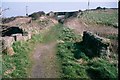
Disused railway, Harrington, West Cumbria
Traffic on the Harrington & Lowca Light Railway was mainly minerals but passengers were carried between 1913 and 1926. This is the site of the former Rosehill Archer Street station where southbound trains were faced with a cruel 285 yds at 1 in 17. In bad weather trains had to set back towards Church Road in order to have a run at the bank. It was the steepest gradient in Britain to have carried adhesion worked passenger trains.
Image: © Ralph Rawlinson
Taken: 2 Apr 2002
0.04 miles
3
Train
Heading for Whitehaven on the Carlisle to Barrow Railway south of Harrington Station
Image: © Alexander P Kapp
Taken: 19 Jun 2007
0.05 miles
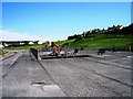
4
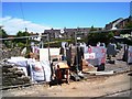
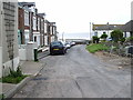
New house under construction, Archer Street
Image: © Alex McGregor
Taken: 18 Jun 2013
0.06 miles
5

Rose Hill, Harrington
On the nearer side of the railings is the railway
Image: © John Lord
Taken: 28 Mar 2009
0.07 miles
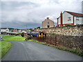
8
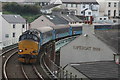
Passenger Train Approaching Harrington Railway Station
To improve capacity at peak times - in particular for Sellafield workers - Northern use a loco hauled train hired from Direct Rail Services on several daily diagrams along the Cumbrian coast. One such service is seen rounding the curve on the approach to Harrington Station.
Image: © David Robinson
Taken: 17 Oct 2015
0.12 miles
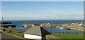
10
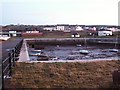
A winter afternoon at Harrington Harbour
The harbour today is mainly used for leisure, but it was once a very busy port. Coal and limestone were exported from Harrington, and an important shipbuilding industry developed. For some fascinating pictures of the harbour's industrial past, see : http://myweb.tiscali.co.uk/photoarchive/index.html
Image: © Rose and Trev Clough
Taken: 29 Nov 2008
0.12 miles