IMAGES TAKEN NEAR TO
WORKINGTON, CA14 2JH
Introduction
This page details the photographs taken nearby to CA14 2JH by members of the Geograph project.
The Geograph project started in 2005 with the aim of publishing, organising and preserving representative images for every square kilometre of Great Britain, Ireland and the Isle of Man.

There are currently over 7.5m images from over14,400 individuals and you can help contribute to the project by visiting https://www.geograph.org.uk
Image Map
Images are licensed for reuse under creativecommons.org/licenses/by-sa/2.0
Notes
- Clicking on the map will re-center to the selected point.
- The higher the marker number, the further away the image location is from the centre of the postcode.
Image Listing (37 Images Found)
Images are licensed for reuse under creativecommons.org/licenses/by-sa/2.0
Image
Details
Distance
3
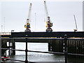
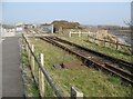
Workington Dock or Harbour Bridge
The north eastern part of this combined railway and footpath bridge crosses the River Derwent. The bridge carries the railway from Workington Steelworks to Workington Dock, mainly used for transporting rails for export. The footpath leads from Curwen Road to Northside and is part of the Cumbria Coastal Way; National Cycle Route 71 also follows the same very narrow path.
Image: © Adrian Taylor
Taken: 19 Mar 2009
0.05 miles
4
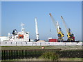
Workington Docks
The "Arctic Sky" being unloaded,
Image: © Alexander P Kapp
Taken: 3 May 2007
0.06 miles
5
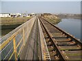
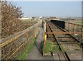
Railway into Workington Docks
The railway is mainly used for transporting steel rails for export and connects Workington Docks with the internal Workington Steelworks railway system, via the Workington Dock or Harbour Bridge.
The footpath leads from Curwen Road to Northside, it is also the Cumbria Coastal Way and part of National Cycle Route 71.
Image: © Adrian Taylor
Taken: 19 Mar 2009
0.06 miles
6
Workington Dock or Harbour Bridge
The railway and footpath bridge is in two distinct halves either side of the tip of the disused Merchant’s Quay which it crosses. The south western section was originally a swing bridge allowing boats to access Workington Harbour. The bridge carries the railway from Workington Steelworks to Workington Dock, mainly used for transporting rails for export. The footpath leads from Curwen Road to Northside and is also the Cumbria Coastal Way; National Cycle Route 71 also follows the same very narrow path.
Image: © Adrian Taylor
Taken: 19 Mar 2009
0.06 miles
7
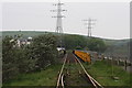
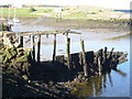
Rail Bridge
Crossing the River Derwent, this line is now disused, as the steel works it serviced are closing. A narrow foot/cycle way has been created to the right, forming part of the C2C cycleway.
This bridge was badly damaged during the floods of 2009, and is currently closed to all users. It is due to be demolished and replaced by a foot and cycle bridge.
Image: © Bob Jenkins
Taken: 10 May 2008
0.07 miles
8
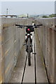
Narrow Bridge
This foot/cycle bridge over the River Derwent was formed by fencing off a slice adjacent to the train line. It is part of the C2C cycleway, but difficult to ride across.
This bridge was badly damaged during the floods of 2009, and is currently closed to all users. It is due to be demolished and replaced by a foot and cycle bridge.
Image: © Bob Jenkins
Taken: 10 May 2008
0.07 miles
9
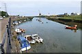
Low tide at Workington Harbour
A variety of working and pleasure boats moored at the quay.
Image: © Russel Wills
Taken: 8 Jun 2018
0.07 miles
10
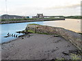
River Derwent & the Capstan Jetty
Built in the mid 18thC for the coal industry and next to the ship yards, it would once have had a capstan on the end to help wooden sailing ships tie up. Now only pleasure craft pass by on this side of the river.
On the opposite bank is the dock keepers house, where prior to 1926 the entrance to the Lonsdale Dock was. The change can just be established, as to the right there is mortared stone walling, and to the left concrete with additional rubble stones to protect it from tides. This was done when the dock was enlarged, reconstructed and deepened due to the increased size of ships that were importing ores from Spain and South America.
Image: © Matthew Hatton
Taken: 3 Jun 2017
0.08 miles