IMAGES TAKEN NEAR TO
London Road, CARLISLE, CA1 3ET
Introduction
This page details the photographs taken nearby to London Road, CA1 3ET by members of the Geograph project.
The Geograph project started in 2005 with the aim of publishing, organising and preserving representative images for every square kilometre of Great Britain, Ireland and the Isle of Man.

There are currently over 7.5m images from over14,400 individuals and you can help contribute to the project by visiting https://www.geograph.org.uk
Image Map
Images are licensed for reuse under creativecommons.org/licenses/by-sa/2.0
Notes
- Clicking on the map will re-center to the selected point.
- The higher the marker number, the further away the image location is from the centre of the postcode.
Image Listing (26 Images Found)
Images are licensed for reuse under creativecommons.org/licenses/by-sa/2.0
Image
Details
Distance
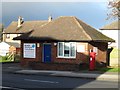
1

Former police post, London Road
This police substation in Harraby became surplus to requirements several years ago, and was sold. It is now used as business premises.
Image: © Rose and Trev Clough
Taken: 31 Jul 2011
0.00 miles
2
Former Police Post, London Road, Carlisle
This small building on London Road was once a police post. It is now being used as an office by a small business.
Image: © Graham Robson
Taken: 3 Nov 2013
0.01 miles
3
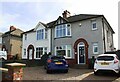
Nos. 288 & 286 London Road
Ordnance Survey records indicate that a benchmark levelled at 36.744m above Newlyn Datum was verified in 1972 on the side of the right hand house at its back corner
Image: © Luke Shaw
Taken: 24 Aug 2019
0.03 miles
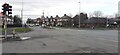
4
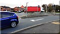
Junction of London Road (A6) and Eastern Way
Image: © Roger Templeman
Taken: 21 Oct 2021
0.05 miles
5
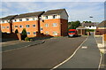
Houses on Cavaghan Gardens
Ordnance Survey records indicate that a flush bracket (serial number 1441) was levelled at 41.897m above Newlyn Datum in 1953 and verified in 1972 on a building beside a factory at this site. The buildings were demolished in ~2009 to make way for the new housing. See www.bench-marks.org.uk/bm10278
Image: © Luke Shaw
Taken: 24 Aug 2019
0.08 miles
6
London Road at Eastern Way junction
Ordnance Survey documents indicate that a benchmark was levelled at 119.392 feet above Liverpool Datum on a gatepost here (before Eastern Way was constructed) during the Ordnance Survey 1GL 1841-1844 Liverpool to Port Carlisle Survey. The surveyor's description was 'No. 464. Mark on pier of gate at East side of road ; 4.82 ft. above surface'
Image: © Roger Templeman
Taken: 8 Feb 2022
0.08 miles
7
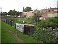
Allotments off Eastern Way
The building to the right is part of the Cavaghan and Gray food factory (commonly known as Cavvies). In the distance at the far left is Image
Image: © Rose and Trev Clough
Taken: 1 Aug 2009
0.10 miles
8
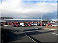
Aldi, Petteril Bank Road, Carlisle
An Aldi supermarket accessed off Petteril Bank Road, Carlisle.
Image: © Graham Robson
Taken: 3 Nov 2013
0.15 miles
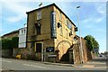
9
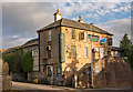
Harraby Inn, Harraby, Carlisle - October 2017
A former private house known as "Harraby Grange", this late 19th Century property was acquired by the State Management Scheme and opened as a pub on 25 June 1949. Sold to Scottish & Newcastle on 17 April 1973, it recently closed and is currently for let.
Photograph is for record only - I have no connection with any parties dealing in the disposal of this property and cannot advise on their products or services.
Image: © The Carlisle Kid
Taken: 29 Oct 2017
0.16 miles
10
Harraby pub and kitchen at junction of London Road and Harraby Grove
There is an Ordnance Survey benchmark Image on the wall of the pub under the Harraby Grove road name sign
Image: © Roger Templeman
Taken: 24 Aug 2019
0.17 miles