IMAGES TAKEN NEAR TO
Lightfoot Drive, CARLISLE, CA1 3BH
Introduction
This page details the photographs taken nearby to Lightfoot Drive, CA1 3BH by members of the Geograph project.
The Geograph project started in 2005 with the aim of publishing, organising and preserving representative images for every square kilometre of Great Britain, Ireland and the Isle of Man.

There are currently over 7.5m images from over14,400 individuals and you can help contribute to the project by visiting https://www.geograph.org.uk
Image Map
Images are licensed for reuse under creativecommons.org/licenses/by-sa/2.0
Notes
- Clicking on the map will re-center to the selected point.
- The higher the marker number, the further away the image location is from the centre of the postcode.
Image Listing (31 Images Found)
Images are licensed for reuse under creativecommons.org/licenses/by-sa/2.0
Image
Details
Distance
2
Carlisle, Barnardo's Community House
Sure Start Centre on Blundell Road: http://www.barnardos.org.uk/carlislesouthcc.htm
Image: © Mike Faherty
Taken: 15 May 2012
0.07 miles
3
Carlisle, Google Earth car
On Welsh Road, preparing for a day's work re-surveying Carlisle's suburbs.
Image: © Mike Faherty
Taken: 15 May 2012
0.08 miles
4
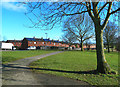
Open Space Near Carleton
This area of open space lies high above the River Petteril on the south side of Carlisle. The houses in the background lie along the A6.
Image: © Mary and Angus Hogg
Taken: 20 Feb 2018
0.11 miles
5
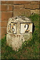
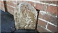
Carlisle Milestone
Beside London Road; 2 miles from Carlisle and 16 miles to Penrith.
Image: © David Rogers
Taken: 8 Oct 2009
0.12 miles
6
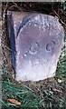
Carlisle city boundary stone, London Road
Red sandstone marker located between Nos 417 and 419 London Road. Inscribed : CC 1912. In that year the municipal borough and civil parish of Carlisle was extended, taking in the townships of Harraby, Upperby, and Botcherby together with parts of Belle Vue, Cummersdale and Stanwix (Kelly's directory of Cumberland and Westmorland, 1914).
Image: © Rose and Trev Clough
Taken: 3 Oct 2016
0.12 miles
7
1912 City of Carlisle boundary stone on NE side of London Road
In grass verge of the A6 on the line of the northern boundary of #419 London Road, the stone has the Milestone Society National ID: CU_CL03pb
Image: © Roger Templeman
Taken: 21 Oct 2021
0.12 miles
8
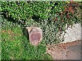
Old GPO telephone cable marker (4), close up
For setting, see Image .
An Edwardian relic, installed by the General Post Office (GPO) to show the location of an underground telephone cable or junction.
For information, see a similar but more exposed specimen below Summer Hill Image .
Image: © Rose and Trev Clough
Taken: 3 Oct 2016
0.13 miles
9
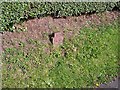
Old GPO telephone cable marker, London Road (4)
A rusty metal post, sticking out of the grassy bank on the left. On London Road (A6) at Harraby, heading out of town.
For more detail see Image .
There is another one of these, more prominent, on the same stretch of road Image . Also two more closer to town http://www.geograph.org.uk/photo/5222637 & http://www.geograph.org.uk/photo/5222638 .
Image: © Rose and Trev Clough
Taken: 3 Oct 2016
0.13 miles
10
Carleton face of Carleton/Harraby boundary stone on NE side of London Road
The Harraby face is at Image and history of stone at Image
Milestone Society National ID: CU_PRCL15pb
Image: © Roger Templeman
Taken: 21 Oct 2021
0.13 miles