IMAGES TAKEN NEAR TO
Low Lorton, COCKERMOUTH, CA13 9UP
Introduction
This page details the photographs taken nearby to CA13 9UP by members of the Geograph project.
The Geograph project started in 2005 with the aim of publishing, organising and preserving representative images for every square kilometre of Great Britain, Ireland and the Isle of Man.

There are currently over 7.5m images from over14,400 individuals and you can help contribute to the project by visiting https://www.geograph.org.uk
Image Map
Images are licensed for reuse under creativecommons.org/licenses/by-sa/2.0
Notes
- Clicking on the map will re-center to the selected point.
- The higher the marker number, the further away the image location is from the centre of the postcode.
Image Listing (35 Images Found)
Images are licensed for reuse under creativecommons.org/licenses/by-sa/2.0
Image
Details
Distance
1
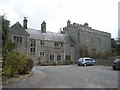
Winder Hall Country House Hotel and Restaurant
Based on a Jacobean manor house. http://www.winderhall.co.uk/
Image: © Oliver Dixon
Taken: 10 Apr 2008
0.01 miles
4
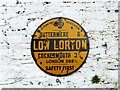
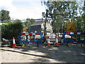
AA village sign, Low Lorton
During the early decades of the 20th century, the Automobile Association erected thousands of signs like this in towns and villages throughout the country. The vast majority were taken down during World War II, and few survived. For information and a splendid gallery, see Colne Valley Postal History Museum website : http://www.cvphm.org.uk/AAVillageSigns.html .
The sign is located here Image . It certainly looks old, but we couldn't say if this was its original position - it does not appear on a photo taken in 2002 http://www.imagesofengland.org.uk/details/default.aspx?id=72672 .
Image: © Rose and Trev Clough
Taken: 10 May 2011
0.09 miles
5
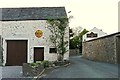
Barn converted to garage, Low Lorton
The barn is part of a private residence, originally a farmhouse http://www.imagesofengland.org.uk/details/default.aspx?id=72672 . On the B5289, which narrows towards Image .
For a closer look at the yellow sign on the wall, see Image .
Image: © Rose and Trev Clough
Taken: 10 May 2011
0.09 miles
6
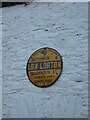
Old AA Sign on the B5289 in Low Lorton
Old AA Sign set on the wall of a garage attached to a house on the west side of the B5289 in Low Lorton. Lorton parish. There were five series of AA signs, mostly dating from 1923 and made by Francis & Co / Franco in Deptford, London. The village name and distance to London were displayed.
Milestone Society National ID: CB-LLORT
Image: © M Rayner
Taken: 1 Jan 2017
0.09 miles
7
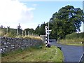
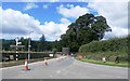
Low Lorton Junction
The view on the B5289 Buttermere to Cockermouth road.
Image: © Gordon Griffiths
Taken: 11 Sep 2012
0.09 miles
8
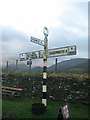
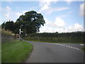
Old Direction Sign - Signpost by the B5289, Low Lorton, Lorton Parish
Annulus finial - 3 arms; by the B5289, in parish of Lorton (Allerdale District), Low Lorton, on grass verge.
Surveyed
Milestone Society National ID: CU_NY1525B.
Image: © Milestone Society
Taken: Unknown
0.09 miles
10
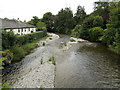
Lorton Low Bridge
This bridge was swept away in the November 2009 floods and a new bridge is seen under construction. Until complete, some journeys in the area require quite long detours.
As far as I can see, there is no photo of the former bridge (a twin-arched stone bridge with a central pier in the river, which was Grade II listed) on the Geograph site. A pity!
The completed new bridge can be seen in Image
Image: © David Purchase
Taken: 8 Sep 2010
0.10 miles