IMAGES TAKEN NEAR TO
Cocktons Yard, COCKERMOUTH, CA13 9LN
Introduction
This page details the photographs taken nearby to Cocktons Yard, CA13 9LN by members of the Geograph project.
The Geograph project started in 2005 with the aim of publishing, organising and preserving representative images for every square kilometre of Great Britain, Ireland and the Isle of Man.

There are currently over 7.5m images from over14,400 individuals and you can help contribute to the project by visiting https://www.geograph.org.uk
Image Map
Images are licensed for reuse under creativecommons.org/licenses/by-sa/2.0
Notes
- Clicking on the map will re-center to the selected point.
- The higher the marker number, the further away the image location is from the centre of the postcode.
Image Listing (448 Images Found)
Images are licensed for reuse under creativecommons.org/licenses/by-sa/2.0
Image
Details
Distance
1
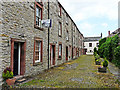
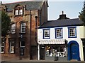
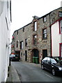
Cockton's Yard
A row of early 19th century workers' houses, built on what was a medieval burgage plot (long narrow strip of land behind a town house fronting onto the street). Pedestrian access to the yard is a passageway between shops on Main Street, modern residents also have car parking spaces to the rear.
The scene doesn't appear to have changed since this photo was taken in 2003 Image .
Image: © Rose and Trev Clough
Taken: 27 Jun 2014
0.00 miles
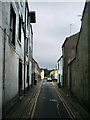
3
The History Wall
The view in Kings Arms Lane off Main Street, Cockermouth.
Image: © Gordon Griffiths
Taken: 10 Sep 2012
0.01 miles
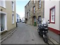
4
The Old Kings Arms Lane
The view in Kings Arms courtyard off Main Street, Cockermouth.
Image: © Gordon Griffiths
Taken: 10 Sep 2012
0.01 miles
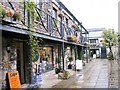
5
Shops in Main Street Cockermouth
Afternoon sunshine lit up the shops in Cockermouth.
Image: © Jennifer Petrie
Taken: 14 Oct 2019
0.01 miles
7
Waterloo Street, Cockermouth
Heading WSW
Image: © Kenneth Allen
Taken: 20 Apr 2013
0.02 miles
8
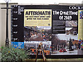
Flood story, Old Kings Arms Lane
This is the first panel in the display shown here Image .
In this lane, the November 2009 flood water reached a height of 1.7m (5ft 8in), the highest level elsewhere in the town was 2.44m (8ft).
Image: © Rose and Trev Clough
Taken: 25 Oct 2014
0.03 miles
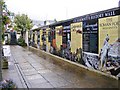
9
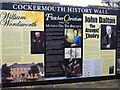
Cockermouth History Wall
Lots of interesting local history can be read here.
Image: © Jennifer Petrie
Taken: 14 Oct 2019
0.03 miles
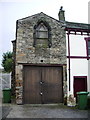
10
Old mill Waterloo Street
Now converted into housing
Image: © Alexander P Kapp
Taken: 4 Sep 2007
0.03 miles