IMAGES TAKEN NEAR TO
Carliol Drive, CARLISLE, CA1 2RD
Introduction
This page details the photographs taken nearby to Carliol Drive, CA1 2RD by members of the Geograph project.
The Geograph project started in 2005 with the aim of publishing, organising and preserving representative images for every square kilometre of Great Britain, Ireland and the Isle of Man.

There are currently over 7.5m images from over14,400 individuals and you can help contribute to the project by visiting https://www.geograph.org.uk
Image Map
Images are licensed for reuse under creativecommons.org/licenses/by-sa/2.0
Notes
- Clicking on the map will re-center to the selected point.
- The higher the marker number, the further away the image location is from the centre of the postcode.
Image Listing (29 Images Found)
Images are licensed for reuse under creativecommons.org/licenses/by-sa/2.0
Image
Details
Distance
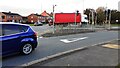
1
London Road at Eastern Way junction
Ordnance Survey documents indicate that a benchmark was levelled at 119.392 feet above Liverpool Datum on a gatepost here (before Eastern Way was constructed) during the Ordnance Survey 1GL 1841-1844 Liverpool to Port Carlisle Survey. The surveyor's description was 'No. 464. Mark on pier of gate at East side of road ; 4.82 ft. above surface'
Image: © Roger Templeman
Taken: 8 Feb 2022
0.08 miles
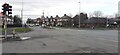
2
Junction of London Road (A6) and Eastern Way
Image: © Roger Templeman
Taken: 21 Oct 2021
0.09 miles
3
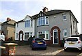
Nos. 288 & 286 London Road
Ordnance Survey records indicate that a benchmark levelled at 36.744m above Newlyn Datum was verified in 1972 on the side of the right hand house at its back corner
Image: © Luke Shaw
Taken: 24 Aug 2019
0.10 miles
4
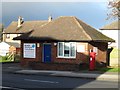
Harraby pub and kitchen at junction of London Road and Harraby Grove
There is an Ordnance Survey benchmark Image on the wall of the pub under the Harraby Grove road name sign
Image: © Roger Templeman
Taken: 24 Aug 2019
0.12 miles
5

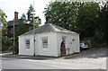
Former police post, London Road
This police substation in Harraby became surplus to requirements several years ago, and was sold. It is now used as business premises.
Image: © Rose and Trev Clough
Taken: 31 Jul 2011
0.13 miles
6
Former Police Post, London Road, Carlisle
This small building on London Road was once a police post. It is now being used as an office by a small business.
Image: © Graham Robson
Taken: 3 Nov 2013
0.13 miles
7
The Lodge, London Road at Chertsey Grove junction
Ordnance Survey documents indicate that a benchmark was levelled at 120.727 feet above Liverpool Datum on the near corner of this former toll house during the 1841-1844 Liverpool to Port Carlisle 1GL Survey. The surveyor's description of the mark was 'No. 465. Bolt in North-west corner of Harraby Toll-house ; 2.65 ft. above surface'. See www.bench-marks.org.uk/bm80950
Image: © Roger Templeman
Taken: 24 Aug 2019
0.13 miles
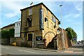
8

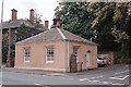
Former toll cottage, London Road
Built in 1830 for the keeper of the Harraby Toll Gate, on the Carlisle to Eamont Bridge turnpike road (for information on turnpikes see Wikipedia http://en.wikipedia.org/wiki/Turnpike_trust ) .
The turnpike closed in 1883, when road maintenance became the responsibility of the local authority. The cottage was sold to the owner of nearby Chertsey House, to be used as a lodge.
Today it is a private residence.
Image: © Rose and Trev Clough
Taken: 31 Jul 2011
0.13 miles
9
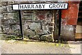
Benchmark on the Harraby Grove face of the Harraby Pub
Ordnance Survey cut mark benchmark described on the Bench Mark Database at www.bench-marks.org.uk/bm112143
Image: © Roger Templeman
Taken: 24 Aug 2019
0.13 miles
10
Tollhouse by the A6, London Road, Harraby
Tollhouse by the A6 at junction with High Street, Harraby, in the parish of Carlisle (Carlisle District), The Lodge, No. 258, London Road.
Grade II listed.
List Entry Number: 1217845 https://historicengland.org.uk/listing/the-list/list-entry/1217845
To be surveyed
Milestone Society National ID: CB.CAR01
Image: © Milestone Society
Taken: Unknown
0.13 miles