IMAGES TAKEN NEAR TO
Broad Street, CARLISLE, CA1 2AQ
Introduction
This page details the photographs taken nearby to Broad Street, CA1 2AQ by members of the Geograph project.
The Geograph project started in 2005 with the aim of publishing, organising and preserving representative images for every square kilometre of Great Britain, Ireland and the Isle of Man.

There are currently over 7.5m images from over14,400 individuals and you can help contribute to the project by visiting https://www.geograph.org.uk
Image Map
Images are licensed for reuse under creativecommons.org/licenses/by-sa/2.0
Notes
- Clicking on the map will re-center to the selected point.
- The higher the marker number, the further away the image location is from the centre of the postcode.
Image Listing (104 Images Found)
Images are licensed for reuse under creativecommons.org/licenses/by-sa/2.0
Image
Details
Distance
1
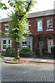
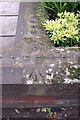
No. 38 Broad Street
Ordnance Survey records indicate that a benchmark levelled at 16.164m above Newlyn Datum was verified low down on the wall then fronting the house in 1972. See www.bench-marks.org.uk/bm102846
Image: © Luke Shaw
Taken: 24 Aug 2019
0.02 miles
2
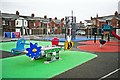
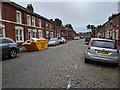
Broad Street play area
Accessed via lanes off Petteril and River Streets.
The playground looks well kept, with plenty of different activities. The City Council rationalised play areas in 2014 - compare Image .
Image: © Rose and Trev Clough
Taken: 18 Jan 2017
0.04 miles
3
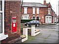
Victorian 'Ludlow' style letter box, Lismore Street
This letter box was made by the Eagle Range and Foundry Company of Birmingham, there are very few of its type still in use around the country. Because they have a similar appearance to letter boxes made by James Ludlow & Son (who produced several thousand over 80 years), the small number of examples by other makers are included in the category 'Ludlow boxes' for convenience. Ludlow boxes were designed for use in sub-post offices. For more information see Colne Valley Postal History Museum http://www.cvphm.org.uk/Ludlows.html and Wikipedia https://en.wikipedia.org/wiki/Ludlow_wall_box .
The location is at the corner of Lismore Street and Broad Street. Now a private house, there was a sub-post office here for many years. It is marked on old OS maps through from 1901 to 1974-76 https://www.old-maps.co.uk/#/Map/340880/555760/12/100685 .
For a closer view, see Image .
Image: © Rose and Trev Clough
Taken: 18 Jan 2017
0.05 miles
4
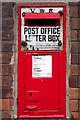
An unusual VR letter box, Lismore Street
For location and some historical background, see Image .
Set in the wall of a former sub-post office. A Ludlow style box, made by the Eagle Range & Foundry Co (probably in the 1880s). For comparison with similar letter box types, there is an excellent gallery at Colne Valley Postal History Museum http://www.cvphm.org.uk/LudlowTour.html . See also Image .
At the bottom of the enamel plaque it says 'NOTICE. Letters which contain COIN if posted as ordinary letters will be charged on delivery with a special registration fee of eightpence'. It probably didn't occur to them to allow for inflation.
Postbox number : CA1 72D.
Image: © Rose and Trev Clough
Taken: 18 Jan 2017
0.05 miles
5
Benchmark on front wall of Rokeby Villa, #124 Warwick Road
Ordnance Survey rivet benchmark described on the Bench Mark Database at http://www.bench-marks.org.uk/bm38340
Image: © Roger Templeman
Taken: 18 Jun 2011
0.05 miles
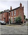
7
Nos. 124 Rokeby Villa and 122 Waverley Villa
Three is an Ordnance Survey benchmark Image at the road end of the party wall between the front gardens of the two houses
Image: © Roger Templeman
Taken: 30 Jul 2021
0.06 miles
8
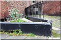
Benchmark on wall of #26 Lismore Street
Ordnance Survey cut mark benchmark described on the Bench Mark Database at http://www.bench-marks.org.uk/bm38338
Image: © Roger Templeman
Taken: 18 Jun 2011
0.06 miles
9
Nos. 28 and 26 Lismore Street
There is an Ordnance Survey benchmark Image on the corner of the black wall in front of the right hand house
Image: © Roger Templeman
Taken: 30 Jul 2021
0.06 miles
10
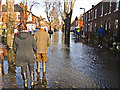
Watching the floodwater level in Broad Street
The far end of this street joins Warwick Road, where deeper flood water had already forced many residents to evacuate.
Image: © Rose and Trev Clough
Taken: 6 Dec 2015
0.07 miles