IMAGES TAKEN NEAR TO
Threlkeld, KESWICK, CA12 4SF
Introduction
This page details the photographs taken nearby to CA12 4SF by members of the Geograph project.
The Geograph project started in 2005 with the aim of publishing, organising and preserving representative images for every square kilometre of Great Britain, Ireland and the Isle of Man.

There are currently over 7.5m images from over14,400 individuals and you can help contribute to the project by visiting https://www.geograph.org.uk
Image Map
Images are licensed for reuse under creativecommons.org/licenses/by-sa/2.0
Notes
- Clicking on the map will re-center to the selected point.
- The higher the marker number, the further away the image location is from the centre of the postcode.
Image Listing (16 Images Found)
Images are licensed for reuse under creativecommons.org/licenses/by-sa/2.0
Image
Details
Distance
1
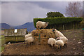
Sheep feeding at High Row Farm
The sheep on top of the pile was definitely "king of the castle" - none of the others were allowed up there! See Image, taken next morning, to see how rapidly the food was being eaten.
Image: © Ian Capper
Taken: 5 Apr 2008
0.02 miles
2
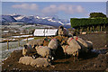
Sheep feeding at High Row Farm
In the distance can be seen the newly snow covered fells above Newlands valley. Compare the height of the pile of food with Image, taken just 15 hours earlier!
Image: © Ian Capper
Taken: 6 Apr 2008
0.02 miles
3
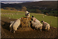
Sheep feeding at High Row Farm
Caught in a patch of afternoon sunshine. On the fellside on the right can be seen Threlkeld Quarry.
Image: © Ian Capper
Taken: 5 Apr 2008
0.02 miles
5
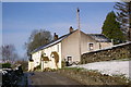
Towards High Row Farm
High Row Farm is the building in the middleground.
Image: © Ian Capper
Taken: 6 Apr 2008
0.04 miles
6
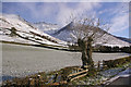
Near High Row Farm
Grasmoor in the background.
Image: © Ian Capper
Taken: 6 Apr 2008
0.05 miles
7

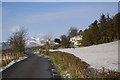
Road to Threlkeld
The minor road to Threlkeld just past High Row Farm with Great Mell Fell on the right and a mobile phone mast to balance it up to the left.
Image: © Jim Barton
Taken: 5 Mar 2012
0.10 miles
8
Pollarded tree
On lane to High Row Farm, with Blencathra behind.
Image: © Ian Capper
Taken: 6 Apr 2008
0.10 miles
9
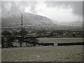
Mobile Phone Mast, Threkeld
The scourge of modern life, ever present even in the Lake District. This one has views down St. John's in the Vale.
Image: © Mick Garratt
Taken: 30 Dec 2005
0.12 miles
10
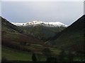
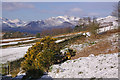
Summit Ridge of Blencathra From High Row
View north from just east of the radio mast. The snow capped summit ridge is bathed in sunlight.
Image: © Mick Garratt
Taken: 1 Jan 2006
0.12 miles