IMAGES TAKEN NEAR TO
Merle Bank, KESWICK, CA12 4RZ
Introduction
This page details the photographs taken nearby to Merle Bank, CA12 4RZ by members of the Geograph project.
The Geograph project started in 2005 with the aim of publishing, organising and preserving representative images for every square kilometre of Great Britain, Ireland and the Isle of Man.

There are currently over 7.5m images from over14,400 individuals and you can help contribute to the project by visiting https://www.geograph.org.uk
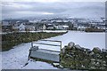
Image Map
Images are licensed for reuse under creativecommons.org/licenses/by-sa/2.0
Notes
- Clicking on the map will re-center to the selected point.
- The higher the marker number, the further away the image location is from the centre of the postcode.
Image Listing (95 Images Found)
Images are licensed for reuse under creativecommons.org/licenses/by-sa/2.0
Image
Details
Distance
1

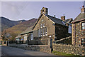
Old School House
See Image for background. Now a holiday cottage.
Image: © Ian Capper
Taken: 12 Apr 2008
0.02 miles
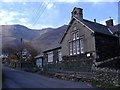
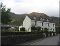
2
Threlkeld C of E Primary School
Until 1776 village children were taught in the chancel of the church (see Image). However, when this was demolished, a school house was built in Blease Road for boys only (see Image). In 1842 an upper floor was added for girls. In 1849 the school moved across the road to the new buildings shown here.
Image: © Ian Capper
Taken: 8 Apr 2008
0.02 miles
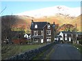
3
Threlkeld school
A Church of England primary school, with Blencathra as a backdrop.
Image: © Roger Cornfoot
Taken: 2 Apr 2007
0.03 miles
4
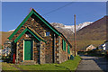
Mission Room
Dating from 1885 when it was built by the Keswick & District Christian Workers Band, the building served as the Methodist chapel until June 1959. Now a private house.
Image: © Ian Capper
Taken: 8 Apr 2008
0.04 miles
5
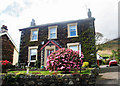
House in Threlkeld
With rhododendron in full bloom.
Image: © Helen Wilkinson
Taken: 30 Apr 2009
0.04 miles
6
Feeding Trough, Threlkeld
Clough Head in the distance.
Image: © Mick Garratt
Taken: 29 Dec 2009
0.06 miles
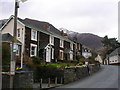
7
Stuart Villas, Threlkeld
The short terrace of houses has a date stone of 1902. Gategill Fell in the background.
Image: © E Gammie
Taken: 22 Aug 2018
0.06 miles
8
Threlkeld and Knowe Crags
Threlkeld is dominated by Blencathra (of which Knowe Crags form a westerly spur), one of the most imposing mountains in the Lake District.
Image: © Oliver Dixon
Taken: 10 Dec 2007
0.06 miles
9
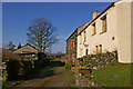
Overlooked by Blencathra
Cottages in Threlkeld
Image: © John H Darch
Taken: 27 Mar 2009
0.06 miles
10
Town Head
A row of cottages off Blease Road.
Image: © Ian Capper
Taken: 8 Apr 2008
0.07 miles