IMAGES TAKEN NEAR TO
Hartington Street, CARLISLE, CA1 1NE
Introduction
This page details the photographs taken nearby to Hartington Street, CA1 1NE by members of the Geograph project.
The Geograph project started in 2005 with the aim of publishing, organising and preserving representative images for every square kilometre of Great Britain, Ireland and the Isle of Man.

There are currently over 7.5m images from over14,400 individuals and you can help contribute to the project by visiting https://www.geograph.org.uk
Image Map
Images are licensed for reuse under creativecommons.org/licenses/by-sa/2.0
Notes
- Clicking on the map will re-center to the selected point.
- The higher the marker number, the further away the image location is from the centre of the postcode.
Image Listing (135 Images Found)
Images are licensed for reuse under creativecommons.org/licenses/by-sa/2.0
Image
Details
Distance
1
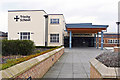
Trinity School, main entrance
Located in Strand Road.
Image: © Rose and Trev Clough
Taken: 18 Feb 2018
0.04 miles
2
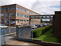
Carlisle College
The bridge across Strand Road links two of the main buildings of this FE college. Seen from the corner of Compton Street.
Image: © Derek Harper
Taken: 4 Jul 2007
0.05 miles
3
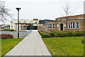
Buildings at Trinity School
Trinity opened as a comprehensive school in 1968, formed by amalgamating Carlisle Grammar School with the neighbouring Creighton (boys) and Margaret Sewell (girls) secondary schools.
Today it is a Church of England Academy, for students aged 11 to 18. School website http://trinity.cumbria.sch.uk/ .
Image: © Rose and Trev Clough
Taken: 18 Feb 2018
0.05 miles
5
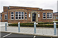
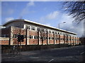
1930s building at Trinity School
This was originally part of Margaret Sewell Girls' School, which opened in 1940. The school amalgamated with Creighton Boys in 1962, then with Carlisle Grammar in 1968 to become Trinity comprehensive.
There are carved stones above the door - see Image .
Image: © Rose and Trev Clough
Taken: 18 Feb 2018
0.05 miles
6
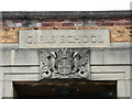
Stone plaques, former Margaret Sewell Girls' School
Over the door to the building shown here Image .
Inscribed "GIRLS' SCHOOL" above the Carlisle City coat of arms.
Margaret Sewell opened in 1940, it became part of Trinity School in 1968.
Image: © Rose and Trev Clough
Taken: 18 Feb 2018
0.05 miles
7
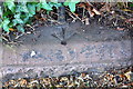
Benchmark on wall at NE corner of Chatsworth Square
Ordnance Survey pivot benchmark described on the Bench Mark Database at http://www.bench-marks.org.uk/bm69219
Image: © Roger Templeman
Taken: 24 Jul 2015
0.06 miles
8
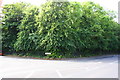
Junction of Chatsworth Square and Victoria Place
There is an OS benchmark Image on top of the low wall at the corner
Image: © Roger Templeman
Taken: 24 Jul 2015
0.06 miles
9
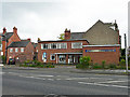
Christian Science Church
On Victoria Place.
Image: © Rose and Trev Clough
Taken: 27 Apr 2014
0.07 miles
10
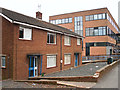
'The Music House', Trinity School
Semi-detached houses in Strand Road. Named on older maps as 'School House' and 'College House', presumably homes for caretakers of the neighbouring establishments (the building on the right is part of Carlisle College).
The houses were used in later years as music practice rooms for Trinity School, but were no longer needed after new facilities were built in 2012.
The properties were demolished a few years after this photo was taken.
Image: © Rose and Trev Clough
Taken: 3 Mar 2013
0.07 miles