IMAGES TAKEN NEAR TO
Calthwaite, PENRITH, CA11 9RX
Introduction
This page details the photographs taken nearby to CA11 9RX by members of the Geograph project.
The Geograph project started in 2005 with the aim of publishing, organising and preserving representative images for every square kilometre of Great Britain, Ireland and the Isle of Man.

There are currently over 7.5m images from over14,400 individuals and you can help contribute to the project by visiting https://www.geograph.org.uk
Image Map
Images are licensed for reuse under creativecommons.org/licenses/by-sa/2.0
Notes
- Clicking on the map will re-center to the selected point.
- The higher the marker number, the further away the image location is from the centre of the postcode.
Image Listing (6 Images Found)
Images are licensed for reuse under creativecommons.org/licenses/by-sa/2.0
Image
Details
Distance
1
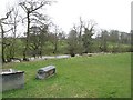
River Petteril, Plumptonfoot
Sheep feeding rack beside the river.
Image: © Richard Webb
Taken: 30 Mar 2008
0.11 miles
2
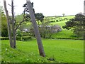
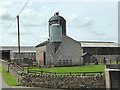
Farm buildings at Plumptonfoot
The infant River Petteril in the floor of the valley.
Image: © Oliver Dixon
Taken: 17 May 2018
0.14 miles
3
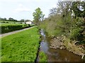
River Petteril at Plumptonfoot
Looking downstream.
Image: © Oliver Dixon
Taken: 17 May 2018
0.14 miles
4
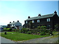
Aikbank Cottages
Probably built in the 1950s 60s as council houses for workers in rural areas, now privately owned.
Image: © Alexander P Kapp
Taken: 9 Jun 2006
0.16 miles
6
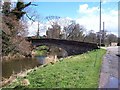
Road bridge at Plumpton Foot.
With the Mill hiding in the trees in the background.
Image: © John Holmes
Taken: 4 Apr 2006
0.19 miles