IMAGES TAKEN NEAR TO
Castlerigg View, PENRITH, CA11 9RP
Introduction
This page details the photographs taken nearby to Castlerigg View, CA11 9RP by members of the Geograph project.
The Geograph project started in 2005 with the aim of publishing, organising and preserving representative images for every square kilometre of Great Britain, Ireland and the Isle of Man.

There are currently over 7.5m images from over14,400 individuals and you can help contribute to the project by visiting https://www.geograph.org.uk
Image Map
Images are licensed for reuse under creativecommons.org/licenses/by-sa/2.0
Notes
- Clicking on the map will re-center to the selected point.
- The higher the marker number, the further away the image location is from the centre of the postcode.
Image Listing (14 Images Found)
Images are licensed for reuse under creativecommons.org/licenses/by-sa/2.0
Image
Details
Distance
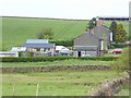
2
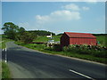
Castle Rigg view
Roadside houses at Low Plains.
Image: © Mary and Angus Hogg
Taken: 10 Aug 2024
0.02 miles
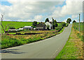
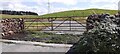
3
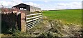
Gateway to field opposite Castle Rigg View
Image: © Roger Templeman
Taken: 2 Aug 2022
0.06 miles
4
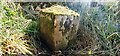
Parish boundary stone on south side of road near Pears Ghyll Farm
The left hand (moss covered) face is inscribed LAZONBY, the right hand face PLUMPTON. The stone has Milestone Society National ID: CU_HESLAZ01pb.
Plumpton, or Plumpton Wall, was a chapelry in Lazonby parish before it became a parish in 1866, and became part of Hesket parish in 1938.
Image: © Roger Templeman
Taken: 2 Aug 2022
0.11 miles
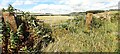
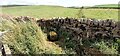
5
Drain
Looking northalong the drainage ditch, with the sand quarry in the distance
Image: © Alexander P Kapp
Taken: 9 Jun 2006
0.11 miles
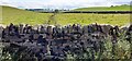
6
Field ditch forming Lazonby/Plumpton parish boundary viewed from road bridge
There is a boundary stone Image marking the boundary on the left bank of the beck
Image: © Roger Templeman
Taken: 2 Aug 2022
0.11 miles
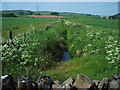
7
Stream channel in field marking parish boundary on north side of road at Low Plains
Image: © Luke Shaw
Taken: 2 Aug 2022
0.12 miles
8
Field gateway from SE side of rural road NE of Pears Ghyll Farm
Image: © Roger Templeman
Taken: 2 Aug 2022
0.22 miles
9
Field gateway on south side road at Pears Ghyll Farm
There is an Ordnance Survey benchmark Image on the inside face of the stone gatepost
Image: © Roger Templeman
Taken: 2 Aug 2022
0.22 miles
10
Road Junction
As you can see the junction is heavily used by the state of the road, traffic entering the road from the left, is coming from a sand quarry and a water bottling plant.
Image: © Alexander P Kapp
Taken: 9 Jun 2006
0.23 miles