IMAGES TAKEN NEAR TO
Hutton Roof, PENRITH, CA11 0XY
Introduction
This page details the photographs taken nearby to CA11 0XY by members of the Geograph project.
The Geograph project started in 2005 with the aim of publishing, organising and preserving representative images for every square kilometre of Great Britain, Ireland and the Isle of Man.

There are currently over 7.5m images from over14,400 individuals and you can help contribute to the project by visiting https://www.geograph.org.uk
Image Map
Images are licensed for reuse under creativecommons.org/licenses/by-sa/2.0
Notes
- Clicking on the map will re-center to the selected point.
- The higher the marker number, the further away the image location is from the centre of the postcode.
Image Listing (11 Images Found)
Images are licensed for reuse under creativecommons.org/licenses/by-sa/2.0
Image
Details
Distance
1
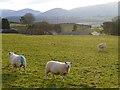
Pasture, Castle Sowerby
A view from the road at How Hill towards Souther Fell and Clough Head.
Image: © Andrew Smith
Taken: 29 Nov 2012
0.06 miles
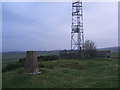
2
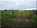
Access point for How Hill communication mast
Image: © Alexander P Kapp
Taken: 16 Sep 2007
0.18 miles
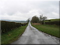
3
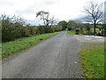
Minor road at How Hill
Looking south-eastward.
Image: © Peter Wood
Taken: 10 Oct 2020
0.19 miles
4
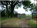
Footpath to Lamonby Quarries
The quarries have open access status
Image: © Alexander P Kapp
Taken: 16 Sep 2007
0.19 miles
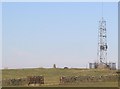
6

How Hill with its Communications Mast and Triangulation Pillar
Looking north-eastward.
Image: © Peter Wood
Taken: 10 Oct 2020
0.21 miles
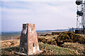
7
Trig point and challenger.
A hollow attempt to be bigger and better?
Image: © John Holmes
Taken: 29 Jan 2006
0.23 miles
9

How Hill Trig Point Flush Bracket S6996
Image: © thejackrustles
Taken: 31 Oct 2021
0.24 miles
10
Trig point at How Hill
How Hill is a modest elevation rising to 317 m. where there's the trig point (FB No. S6996), and a telecoms mast.
Image: © Trevor Littlewood
Taken: 8 Apr 2002
0.24 miles