IMAGES TAKEN NEAR TO
Mungrisdale, PENRITH, CA11 0XF
Introduction
This page details the photographs taken nearby to CA11 0XF by members of the Geograph project.
The Geograph project started in 2005 with the aim of publishing, organising and preserving representative images for every square kilometre of Great Britain, Ireland and the Isle of Man.

There are currently over 7.5m images from over14,400 individuals and you can help contribute to the project by visiting https://www.geograph.org.uk
Image Map
Images are licensed for reuse under creativecommons.org/licenses/by-sa/2.0
Notes
- Clicking on the map will re-center to the selected point.
- The higher the marker number, the further away the image location is from the centre of the postcode.
Image Listing (7 Images Found)
Images are licensed for reuse under creativecommons.org/licenses/by-sa/2.0
Image
Details
Distance
4
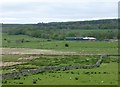
Old Road leading to Bowscale Moss
In the distance is Black Crag on the eastern end of Carrock Fell.
Image: © Matthew Hatton
Taken: 18 May 2016
0.15 miles
5

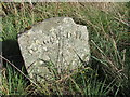
Old Boundary Marker, Mungrisdale parish
Parish Boundary Marker by the UC road, in parish of Mungrisdale (Eden District), 400m South of Moss Dyke Farm, on grass verge.
Inscription reads:-
MUNGRISDALE
Grade II listed
List Entry Number: 1319019 https://historicengland.org.uk/listing/the-list/list-entry/1319019
Surveyed
Milestone Society National ID: CU_BERMUN01pb
Image: © Milestone Society
Taken: Unknown
0.18 miles
6
Parish Boundary Stone for Mungrisdale
Image: © Matthew Hatton
Taken: 18 May 2016
0.19 miles
7
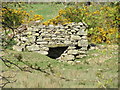
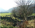
Old Lime Kiln at Low Murrah
Marked on the 1861 OS Map of Cumberland. A small disused quarry is hidden from view by the gorse bushes.
Image: © Matthew Hatton
Taken: 18 May 2016
0.20 miles