IMAGES TAKEN NEAR TO
Newton Reigny, PENRITH, CA11 0FB
Introduction
This page details the photographs taken nearby to CA11 0FB by members of the Geograph project.
The Geograph project started in 2005 with the aim of publishing, organising and preserving representative images for every square kilometre of Great Britain, Ireland and the Isle of Man.

There are currently over 7.5m images from over14,400 individuals and you can help contribute to the project by visiting https://www.geograph.org.uk
Image Map
Images are licensed for reuse under creativecommons.org/licenses/by-sa/2.0
Notes
- Clicking on the map will re-center to the selected point.
- The higher the marker number, the further away the image location is from the centre of the postcode.
Image Listing (32 Images Found)
Images are licensed for reuse under creativecommons.org/licenses/by-sa/2.0
Image
Details
Distance
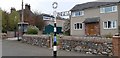
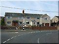
1
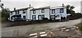
Former George III Inn on south side of Newton Road
Ordnance Survey documents indicate that a benchmerk levelled at 176.424m above Newlyn Datum was verified in 1969 on the front of the building 2.4m from its right hand corner. To the left of the former pub are Nos 1 & 2 Meadow View
Image: © Roger Templeman
Taken: 8 Jul 2022
0.03 miles
2
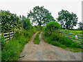
Cart track out of the village, Newton Reigny
This starts as a road from the junction with the signpost shown in Image] and soon becomes a cart track, presumably giving access to fields. It is not shown as a right-of-way on maps, but is probably used by the locals.
Image: © Humphrey Bolton
Taken: 9 Jul 2021
0.04 miles
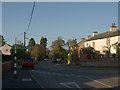
3
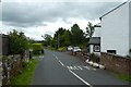
Road east from Newton Reigny
Looking along the road leading towards Newton Rigg and Penrith.
Image: © DS Pugh
Taken: 11 Jul 2020
0.04 miles
4
Newton Reigny
Another example of a Cumberland County Council finger post in excellent condition.
Image: © Richard Webb
Taken: 22 Jul 2019
0.04 miles
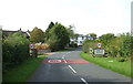
5
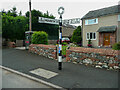
Signpost in Newton Reigny
The fingers indicate that this road has been the B5305, but it is not a B-road now. The B5305 now starts at Junction 41 of the M6 instead of at Penrith.
Image: © Humphrey Bolton
Taken: 9 Jul 2021
0.04 miles
6
Direction Sign ? Signpost
Located on the west side of a T junction in Newton Reigny in Catterlen parish. 2 arms, 1 worboys and annulus finial. See also http://www.geog.port.ac.uk/webmap/thelakes/photos/bzd26.jpg and https://www.geograph.org.uk/photo/2650699.
Milestone Society National ID: CU_NY4731A
Image: © J Glew
Taken: 16 Apr 2019
0.05 miles
7
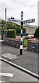
Cumberland County Council finger signpost at junction of B5305 (Newton Road)
The signpost has Milestone Society National ID: CU_NY4731A Image
Image: © Roger Templeman
Taken: 8 Jul 2022
0.05 miles
8
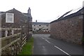
Road Junction Newton Reigny
The road to the right leads away from Newton Reigny and off to Penrith.
Image: © Steve Houldsworth
Taken: 14 Oct 2011
0.05 miles
10
Entering Newton Reigny
Heading west on National Cycle Route 7.
Image: © JThomas
Taken: 10 Oct 2015
0.07 miles