IMAGES TAKEN NEAR TO
Roundthwaite, PENRITH, CA10 3XU
Introduction
This page details the photographs taken nearby to CA10 3XU by members of the Geograph project.
The Geograph project started in 2005 with the aim of publishing, organising and preserving representative images for every square kilometre of Great Britain, Ireland and the Isle of Man.

There are currently over 7.5m images from over14,400 individuals and you can help contribute to the project by visiting https://www.geograph.org.uk
Image Map
Images are licensed for reuse under creativecommons.org/licenses/by-sa/2.0
Notes
- Clicking on the map will re-center to the selected point.
- The higher the marker number, the further away the image location is from the centre of the postcode.
Image Listing (30 Images Found)
Images are licensed for reuse under creativecommons.org/licenses/by-sa/2.0
Image
Details
Distance
1
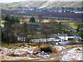
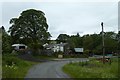
Roundthwaite
The farming hamlet of Roundthwaite is only a field or two away from the M6 and Tebay.
Image: © John H Darch
Taken: 30 Jan 2011
0.05 miles
3
Dropping in to Roundthwaite
From Low Borrowdale, the bridleway is pretty vague for a couple of kilometres before picking up a track for the next couple. The track stays high above the right bank of Roundthwaite Beck until it rounds the end of the spur northeast of Jeffrey's mount whereupon it drops steeply to the road just east of the village where there is handy parking for a couple of cars, enabling visiting walkers to remain safely socially distanced from the local population. This final stretch of the route is a brutal return to civilisation as the major transport corridor of the Lune Valley carries not only the West Coast Main Line, but also (and much more visibly) the noisy M6 motorway. Across the valley lies Tebay.
Image: © Andy Waddington
Taken: 7 Apr 2021
0.08 miles
4
Roundthwaite
View from Jeffrey's Mount with the all too near, and noisy M6.
Image: © Richard Webb
Taken: 19 Dec 2021
0.08 miles
5
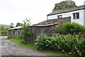
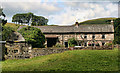
Outbuildings on lane in Roundthwaite
There is an OS benchmark Image on the large stone in the far corner of the near outbuilding
Image: © Roger Templeman
Taken: 11 Aug 2015
0.08 miles
6
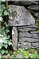
Benchmark on stone block on outbuilding
Ordnance Survey cut mark benchmark described on the Bench Mark Database at http://www.bench-marks.org.uk/bm69777
Image: © Roger Templeman
Taken: 11 Aug 2015
0.08 miles
8
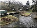
Roundthwaite Ford
This ford is found on the Roundthwaite Beck.
Image: © John Walton
Taken: 10 Jan 2020
0.09 miles
9
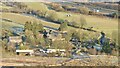
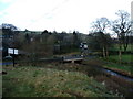
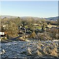
Farms in Roundthwaite
Looking through the village of Roundthwaite situated close to the M6.
Image: © DS Pugh
Taken: 9 Jul 2020
0.10 miles
10
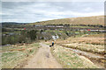
Roundthwaite
View from the track running over the fells to Borrowdale.
Image: © Richard Webb
Taken: 19 Dec 2021
0.10 miles