IMAGES TAKEN NEAR TO
Kings Meaburn, PENRITH, CA10 3DB
Introduction
This page details the photographs taken nearby to CA10 3DB by members of the Geograph project.
The Geograph project started in 2005 with the aim of publishing, organising and preserving representative images for every square kilometre of Great Britain, Ireland and the Isle of Man.

There are currently over 7.5m images from over14,400 individuals and you can help contribute to the project by visiting https://www.geograph.org.uk
Image Map
Images are licensed for reuse under creativecommons.org/licenses/by-sa/2.0
Notes
- Clicking on the map will re-center to the selected point.
- The higher the marker number, the further away the image location is from the centre of the postcode.
Image Listing (18 Images Found)
Images are licensed for reuse under creativecommons.org/licenses/by-sa/2.0
Image
Details
Distance
1
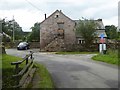
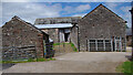
Barn conversion at Littlebeck
With outside steps.
Image: © Oliver Dixon
Taken: 2 Aug 2019
0.01 miles
2
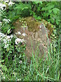
Old Boundary Marker
Parish Boundary Marker at the foot of a hedge between the road junction and a bridge on Littlebeck Lane, Crosby Ravensworth. On the current boundary between Crosby Ravensworth and Kings Meaburn. Inscribed KINGS / MEABURN and MAULDS / MEABURN on opposite faces. Grade II Listed https://historicengland.org.uk/listing/the-list/list-entry/1326765. See also http://www.geograph.org.uk/photo/5299673 and http://www.geog.port.ac.uk/webmap/thelakes/photos/bus21.jpg.
Milestone Society National ID: WE_KMEMME02pb
Image: © Mike Rayner
Taken: 2 Jun 2019
0.01 miles
3
Maulds Meaburn / King's Meaburn parish boundary stone
From the south. Carved 'Mauld Meaburn' on this side, and 'King's Meaburn' on the other. One of several similar stones in the area [for different parishes]. Made of sandstone, Grade 2 listed.
Image: © Christine Johnstone
Taken: 14 Feb 2017
0.01 miles
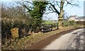
4
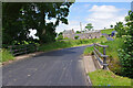
Take heed!
Cul de sac lane leading to a ford over the River Lyvennet Image
Image: © Oliver Dixon
Taken: 2 Aug 2019
0.01 miles
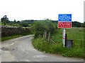
6
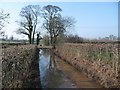
Flooded lane between Peaslands and Littlebeck
Not a very long section of flooding, but deep. Tiptoe alongside the hedge to avoid wet feet!
Image: © Christine Johnstone
Taken: 14 Feb 2017
0.03 miles
7
Llittlebeck
In the foreground is a bridge over Little Beck.
Image: © Ian Taylor
Taken: 22 Jun 2022
0.04 miles
8
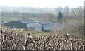
Farm sheds at Littlebeck
Possibly for keeping cattle in, over winter?
Image: © Christine Johnstone
Taken: 14 Feb 2017
0.04 miles
9
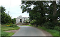
Littlebeck
Farm between Maulds Meaburn and King's Meaburn.
Image: © mauldy
Taken: 13 Aug 2006
0.04 miles
10
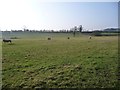
Sheep grazing at Littlebeck
West of the road between the Meaburns.
Image: © Christine Johnstone
Taken: 14 Feb 2017
0.06 miles