IMAGES TAKEN NEAR TO
Clifton Dykes, PENRITH, CA10 2DG
Introduction
This page details the photographs taken nearby to CA10 2DG by members of the Geograph project.
The Geograph project started in 2005 with the aim of publishing, organising and preserving representative images for every square kilometre of Great Britain, Ireland and the Isle of Man.

There are currently over 7.5m images from over14,400 individuals and you can help contribute to the project by visiting https://www.geograph.org.uk
Image Map
Images are licensed for reuse under creativecommons.org/licenses/by-sa/2.0
Notes
- Clicking on the map will re-center to the selected point.
- The higher the marker number, the further away the image location is from the centre of the postcode.
Image Listing (5 Images Found)
Images are licensed for reuse under creativecommons.org/licenses/by-sa/2.0
Image
Details
Distance
1
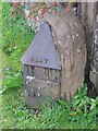
Old Boundary Marker by Wetheriggs, Clifton parish
Parish Boundary Marker by the UC road (was A686), in parish of Clifton (Eden District), by Clifton Dykes Cottages, on verge, South side of road, opposite Moor Lane.
The raised lettering on each face reads:-
1847 / PH OF / (CLIFTON / 1847 broken off)
1847 / PH OF / BROUGHAM / 1847
Grade II listed.
List Entry Number: 1099905 https://historicengland.org.uk/listing/the-list/list-entry/1099905
Surveyed
Milestone Society National ID: WE_ALPR01pb
Image: © M Rayner
Taken: 30 Sep 2017
0.03 miles
2
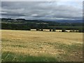
Stubble, High Dykes
Arable land near Penrith. The sun was out here but most surrounding areas were wet. A rain shadow effects, behind the Lake District.
Image: © Richard Webb
Taken: 2 Aug 2018
0.06 miles
4
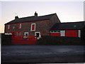
Footpath to High Ground
Rather pointless, as there's a shorter path round the corner.
Image: © Bob Jenkins
Taken: 28 Jan 2006
0.22 miles
5
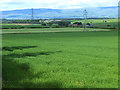
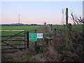
Fields near Clifton Dykes
Pylons stride across the fields. Haversheaf Hall Farm Image in the middle distance, with Whinfell Park Farm Image to the left and beyond. On the skyline is the North Pennines escarpment
Image: © Oliver Dixon
Taken: 11 Jun 2014
0.25 miles