IMAGES TAKEN NEAR TO
Ousby, PENRITH, CA10 1PS
Introduction
This page details the photographs taken nearby to CA10 1PS by members of the Geograph project.
The Geograph project started in 2005 with the aim of publishing, organising and preserving representative images for every square kilometre of Great Britain, Ireland and the Isle of Man.

There are currently over 7.5m images from over14,400 individuals and you can help contribute to the project by visiting https://www.geograph.org.uk
Image Map
Images are licensed for reuse under creativecommons.org/licenses/by-sa/2.0
Notes
- Clicking on the map will re-center to the selected point.
- The higher the marker number, the further away the image location is from the centre of the postcode.
Image Listing (6 Images Found)
Images are licensed for reuse under creativecommons.org/licenses/by-sa/2.0
Image
Details
Distance
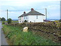
2
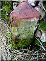
Old Boundary Marker near Crewgarth
Parish Boundary Marker against the cobble wall on the south side of the road at Crewgarth. Inscribed PH OF / OUSBY for parish of Ousby and TN SHIP / OF / HUNSONBY for township of Hunsonby. On the boundary of Hunsonby and Winskill township in Addingham parish and Ousby Parish. This dates the stone earlier than 1866 when Hunsonby and Winskill parish was created. It was called just Hunsonby parish from 1934.
Milestone Society National ID: CU_HUNOUS01pb
Image: © Colin Smith
Taken: 9 Nov 2011
0.09 miles
3
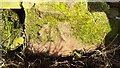
Benchmark on wall on NW side of road at Dry Slack
Ordnance Survey cut mark benchmark levelled at 134.106m above New Datum in 1972
Image: © Luke Shaw
Taken: 2 Dec 2020
0.09 miles
4
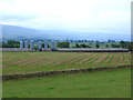
Poultry houses at Crewgarth
Premises of Frank Bird Poultry Ltd based at Crewgarth Farm. The North Pennine escarpment can be seen beyond.
Image: © Oliver Dixon
Taken: 28 Sep 2014
0.10 miles
5
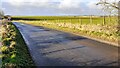
Rural road heading west near Crewgarth
Image: © Roger Templeman
Taken: 2 Dec 2020
0.13 miles
