IMAGES TAKEN NEAR TO
Ousby, PENRITH, CA10 1PR
Introduction
This page details the photographs taken nearby to CA10 1PR by members of the Geograph project.
The Geograph project started in 2005 with the aim of publishing, organising and preserving representative images for every square kilometre of Great Britain, Ireland and the Isle of Man.

There are currently over 7.5m images from over14,400 individuals and you can help contribute to the project by visiting https://www.geograph.org.uk
Image Map
Images are licensed for reuse under creativecommons.org/licenses/by-sa/2.0
Notes
- Clicking on the map will re-center to the selected point.
- The higher the marker number, the further away the image location is from the centre of the postcode.
Image Listing (6 Images Found)
Images are licensed for reuse under creativecommons.org/licenses/by-sa/2.0
Image
Details
Distance
2
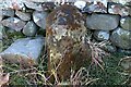
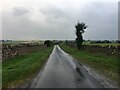
Old Boundary Marker near Ellercow
Parish Boundary Marker against the bridge parapet over Little Briggle Beck, on the west side of the road southeast of Ellercow. Inscribed TOWNSHIP / OF / HUNSONBY and TOWNSHIP / OF / SKIRWITH on adjacent faces. On the boundary of Hunsonby and Skirwith parishes. Skirwith was absorbed into Culgaith parish in 1934. Grade II Listed details https://historicengland.org.uk/listing/the-list/list-entry/1326978. See also https://www.lakesguides.co.uk/photos/CCM19.jpg.
Milestone Society National ID: CU_HUNCUL01pb
Image: © Colin Smith
Taken: 8 Aug 2015
0.08 miles
6
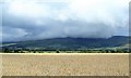
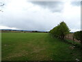
Wheat field near Skirwith
Looking slightly north of east across a wheat field towards the scarp of the north Pennines where cloud hangs over Melmerby Fell.
Image: © Gordon Hatton
Taken: 16 Aug 2018
0.24 miles