IMAGES TAKEN NEAR TO
Hunsonby, PENRITH, CA10 1PP
Introduction
This page details the photographs taken nearby to CA10 1PP by members of the Geograph project.
The Geograph project started in 2005 with the aim of publishing, organising and preserving representative images for every square kilometre of Great Britain, Ireland and the Isle of Man.

There are currently over 7.5m images from over14,400 individuals and you can help contribute to the project by visiting https://www.geograph.org.uk
Image Map
Images are licensed for reuse under creativecommons.org/licenses/by-sa/2.0
Notes
- Clicking on the map will re-center to the selected point.
- The higher the marker number, the further away the image location is from the centre of the postcode.
Image Listing (5 Images Found)
Images are licensed for reuse under creativecommons.org/licenses/by-sa/2.0
Image
Details
Distance
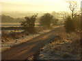
1

The turn off to Hunsonby just before Robberby
Image: © Keith Wright
Taken: 18 Mar 2006
0.15 miles
2
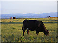
Pasture, Hunsonby
Cattle grazing at Robberby with the eastern fells of the Lake District in the background.
Image: © Andrew Smith
Taken: 29 Jun 2010
0.16 miles
3
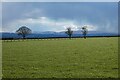
Pasture, Hunsonby
A view towards the eastern fells of the Lake District from Robberby.
Image: © Andrew Smith
Taken: 6 Apr 2021
0.20 miles
4
Farmanby
A lovely farm on the footpath to Broad Meadows
Image: © Keith Wright
Taken: 18 Mar 2006
0.23 miles
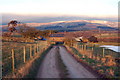
5
Lane at Robberby
The narrow road heads to the A686. The Pennine slopes are just visible through the haze.
Image: © Andrew Smith
Taken: 29 Nov 2008
0.24 miles