IMAGES TAKEN NEAR TO
Salkeld Road, PENRITH, CA10 1ND
Introduction
This page details the photographs taken nearby to Salkeld Road, CA10 1ND by members of the Geograph project.
The Geograph project started in 2005 with the aim of publishing, organising and preserving representative images for every square kilometre of Great Britain, Ireland and the Isle of Man.

There are currently over 7.5m images from over14,400 individuals and you can help contribute to the project by visiting https://www.geograph.org.uk
Image Map
Images are licensed for reuse under creativecommons.org/licenses/by-sa/2.0
Notes
- Clicking on the map will re-center to the selected point.
- The higher the marker number, the further away the image location is from the centre of the postcode.
Image Listing (18 Images Found)
Images are licensed for reuse under creativecommons.org/licenses/by-sa/2.0
Image
Details
Distance
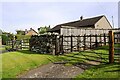
1
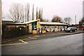
Langwathby C of E School, Salkeld Road
Image: © Roger Templeman
Taken: 19 Feb 2020
0.05 miles
2
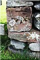
Benchmark on wall on east side of Salkeld Road
Ordnance Survey cut mark benchmark levelled at 101.920m above Newlyn Datum in 1972
Image: © Roger Templeman
Taken: 14 Sep 2020
0.05 miles
3
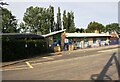
Langwathby CE Primary School, Salkeld Road
Ordnance Survey records indicate that a benchmark was levelled at 98.968m above Newlyn Datum in 1972 on the east face of the building. I suspect the school has been significantly modified since then. See www.bench-marks.org.uk/bm116523
Image: © Roger Templeman
Taken: 14 Sep 2020
0.05 miles
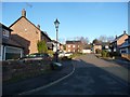
4
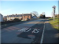
Junction of Salkeld Road and Meadow Court, Langwathby
At the northern end of the village. The 'main' road is part of national cycle route 7.
Image: © Christine Johnstone
Taken: 31 Jan 2019
0.06 miles
5
'Glenavon' on east side of Salkeld Road
There is an Ordnance Survey benchmark Image on a stone at the far end of the short section of dry stone wall
Image: © Roger Templeman
Taken: 14 Sep 2020
0.07 miles
6
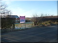
Development land for sale, off Salkeld Road
Room for more houses at the north end of Langwathby.
Image: © Christine Johnstone
Taken: 31 Jan 2019
0.10 miles
7
Track heading east from Salkeld Road
Rising up to a bridge across the Settle Carlisle railway line, giving access to farmland beyond.
Image: © Christine Johnstone
Taken: 31 Jan 2019
0.11 miles
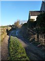
8
End of the pavement, edge of the village
Salkeld Road heading north out of Langwathby, at a 101 metre spot height.
Image: © Christine Johnstone
Taken: 31 Jan 2019
0.12 miles
9
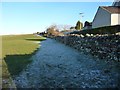
Thin snow in the shadow of a wall, Langwathby
Farmland to the east of Salkeld Road, on a cold winter's afternoon.
Image: © Christine Johnstone
Taken: 31 Jan 2019
0.12 miles
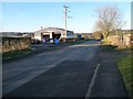
10
Low Farm, Langwathby
A cul-de-sac of houses built by Story Homes in 2002.
Image: © Christine Johnstone
Taken: 31 Jan 2019
0.15 miles