IMAGES TAKEN NEAR TO
Renwick, PENRITH, CA10 1LB
Introduction
This page details the photographs taken nearby to CA10 1LB by members of the Geograph project.
The Geograph project started in 2005 with the aim of publishing, organising and preserving representative images for every square kilometre of Great Britain, Ireland and the Isle of Man.

There are currently over 7.5m images from over14,400 individuals and you can help contribute to the project by visiting https://www.geograph.org.uk
Image Map
Images are licensed for reuse under creativecommons.org/licenses/by-sa/2.0
Notes
- Clicking on the map will re-center to the selected point.
- The higher the marker number, the further away the image location is from the centre of the postcode.
Image Listing (5 Images Found)
Images are licensed for reuse under creativecommons.org/licenses/by-sa/2.0
Image
Details
Distance

3
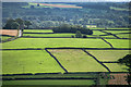
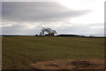
Mooredge
Fields on Mooredge seen from near Scales Rigg.
Image: © Peter McDermott
Taken: 4 Sep 2011
0.13 miles
4
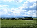
Barley field, Viol Moor
There's a gradual rise from the Vale of Eden eastwards towards the North Pennine scarp, so at this point one is already at the 220m contour. From this crop field one looks over the vale towards the distant Lake District mountains with Blencathra in the centre of the frame.
Image: © Gordon Hatton
Taken: 10 Jun 2019
0.21 miles
5

Field of wheat and two trees above Low Huddlesceugh
The North Pennine escarpment on the skyline.
Image: © Oliver Dixon
Taken: 20 Aug 2014
0.22 miles