IMAGES TAKEN NEAR TO
Kirkoswald, PENRITH, CA10 1ER
Introduction
This page details the photographs taken nearby to CA10 1ER by members of the Geograph project.
The Geograph project started in 2005 with the aim of publishing, organising and preserving representative images for every square kilometre of Great Britain, Ireland and the Isle of Man.

There are currently over 7.5m images from over14,400 individuals and you can help contribute to the project by visiting https://www.geograph.org.uk
Image Map
Images are licensed for reuse under creativecommons.org/licenses/by-sa/2.0
Notes
- Clicking on the map will re-center to the selected point.
- The higher the marker number, the further away the image location is from the centre of the postcode.
Image Listing (8 Images Found)
Images are licensed for reuse under creativecommons.org/licenses/by-sa/2.0
Image
Details
Distance
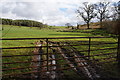
1
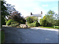
Prospect Hill House
One version of the OS Landranger map identifies this as a public house, but if it ever was, no signs of its former use remain. The site has been redeveloped as a number of barn conversions.
Image: © Oliver Dixon
Taken: 20 Aug 2014
0.01 miles
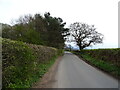
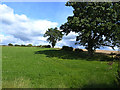
2
Road to Staffield
Westgarth Hill Farm is behind the trees on the hill.
Image: © Bill Boaden
Taken: 7 Mar 2014
0.03 miles
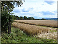
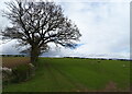
4
Farmland below Westgarth Hill
A drainage channel runs in the depression to the right, but the ground is still very soft.
Image: © Bill Boaden
Taken: 7 Mar 2014
0.08 miles
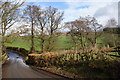
6
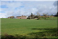
Westgarth Hill Farm
Looking up from Potter's Bank.
Image: © Bill Boaden
Taken: 7 Mar 2014
0.14 miles