IMAGES TAKEN NEAR TO
Kirkoswald, PENRITH, CA10 1EE
Introduction
This page details the photographs taken nearby to CA10 1EE by members of the Geograph project.
The Geograph project started in 2005 with the aim of publishing, organising and preserving representative images for every square kilometre of Great Britain, Ireland and the Isle of Man.

There are currently over 7.5m images from over14,400 individuals and you can help contribute to the project by visiting https://www.geograph.org.uk
Image Map
Images are licensed for reuse under creativecommons.org/licenses/by-sa/2.0
Notes
- Clicking on the map will re-center to the selected point.
- The higher the marker number, the further away the image location is from the centre of the postcode.
Image Listing (109 Images Found)
Images are licensed for reuse under creativecommons.org/licenses/by-sa/2.0
Image
Details
Distance
2
Dated lintel, Kirkoswald
Inscribed 'TA' and 1705, possibly re-used from an older building.
Image: © Humphrey Bolton
Taken: 29 Jan 2009
0.02 miles
3
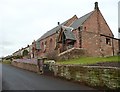
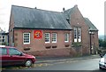
The Methodist Church from the south, Kirkoswald
Built in 1871, with a modern entrance into the chancel.
Image: © Humphrey Bolton
Taken: 29 Jan 2009
0.02 miles
4
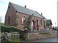
The Methodist Church from the north-west, Kirkoswald
Built in 1871, with a modern entrance into the chancel. There are the remains of a belfry on the west gable and an institutional ventilator on the ridge of the roof.
Image: © Humphrey Bolton
Taken: 29 Jan 2009
0.02 miles
5
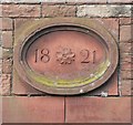
Datestone on the old chapel, Kirkoswald
In 1821 a Wesleyan Chapel was established in what is now two cottages opposite the school. Here is the datestone.
Image: © Humphrey Bolton
Taken: 29 Jan 2009
0.02 miles
6
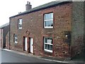
The old Wesleyan chapel, Kirkoswald
In 1821 a Wesleyan Chapel was established in what is now two cottages opposite the school. This building does not look like a chapel, but is opposite the school and is dated 1821 (see Image]).
Image: © Humphrey Bolton
Taken: 29 Jan 2009
0.02 miles
7
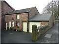
Outbuildings in the village, Kirkoswald (1)
A pleasing set of outbuildings; one can imagine a stable with a hay-loft over, and a 'garage' for a small carriage.
Image: © Humphrey Bolton
Taken: 29 Jan 2009
0.02 miles
8
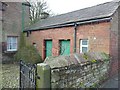
Outbuildings in the village, Kirkoswald (2)
The lintel over the left-hand door has the date 1705 (see Image]), but this might be re-used as the building looks to me to be younger by at least a century.
Image: © Humphrey Bolton
Taken: 29 Jan 2009
0.02 miles
9
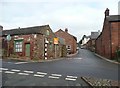
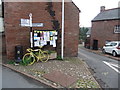
Road junction, Kirkoswald
This is the junction near the top end of the village. The road forward, with the old guide post, is the B6413 to Castle Carrock and Brampton, and the road to the left goes to Armathwaite. There is what looks like a disused shop on the left.
Image: © Humphrey Bolton
Taken: 29 Jan 2009
0.02 miles
10
The Church of England school, Kirkoswald
The original building on the right is dated 1857.
Image: © Humphrey Bolton
Taken: 29 Jan 2009
0.02 miles