IMAGES TAKEN NEAR TO
Ulsterville Avenue, BELFAST, BT9 7LH
Introduction
This page details the photographs taken nearby to Ulsterville Avenue, BT9 7LH by members of the Geograph project.
The Geograph project started in 2005 with the aim of publishing, organising and preserving representative images for every square kilometre of Great Britain, Ireland and the Isle of Man.

There are currently over 7.5m images from over14,400 individuals and you can help contribute to the project by visiting https://www.geograph.org.uk
Image Map
Images are licensed for reuse under creativecommons.org/licenses/by-sa/2.0
Notes
- Clicking on the map will re-center to the selected point.
- The higher the marker number, the further away the image location is from the centre of the postcode.
Image Listing (204 Images Found)
Images are licensed for reuse under creativecommons.org/licenses/by-sa/2.0
Image
Details
Distance
1
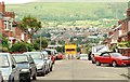
Mount Prospect Park, Belfast (1)
A street of semis close to the Lisburn Road but with no direct vehicular access. The view is towards Ashley Drive. The yellow lorry is collecting glass waste for recycling. See also Image
Image: © Albert Bridge
Taken: 7 Jul 2009
0.01 miles
2
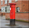
Pillar box, Belfast
An EVIIR pillar box (BT9 261) at Ulsterville Avenue.
Image: © Albert Bridge
Taken: 8 Dec 2013
0.04 miles
3
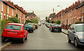
Ashley Drive, Belfast
A short street (close to Tate’s Avenue and the Lisburn Road) built after WWI. The view is up towards Mount Prospect Park Image
Image: © Albert Bridge
Taken: 2 Dec 2009
0.04 miles
4
Ashley Avenue, Belfast
A street of terrace houses off the Lisburn Road. It seems to have developed over a number of years starting before 1880.
Image: © Albert Bridge
Taken: 9 Sep 2009
0.06 miles
5

Belgravia Avenue, Belfast
A short street – of flats and bedsits – off the Lisburn Road.
Image: © Albert Bridge
Taken: 1 Feb 2009
0.06 miles
6
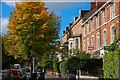
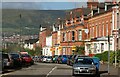
Ulsterville Avenue, Belfast
Off the Lisburn Road, Ulsterville Avenue was once a very genteel place to live. Its proximity to Queen’s University has changed it from an “avenue” to a “street” of houses of multiple occupation. See also Image
Image: © Albert Bridge
Taken: 4 Oct 2007
0.07 miles
7
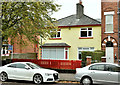
No 49 Ulsterville Avenue, Belfast (October 2017)
A detached house, on the northern side of Ulsterville Avenue, built in the “inter-war” period and recently used as a day nursery. Now the subject of the following application for planning permission (1 September 2017) “LA04/2017/2109/F Demolition of building and construction of residential development comprising 6 one bedroom and 2 two bedroom apartments and ancillary site works 49 Ulsterville Avenue Lisburn Road Belfast BT9 7AT”.
This photograph appears as a matter of neutral record only. I have no connection with the property and express no opinion about the application.
Image: © Albert Bridge
Taken: 15 Oct 2017
0.07 miles
8
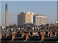
Belfast rooftops
The rooftops of the close-knit terracing on the western side of the Lisburn Road in Belfast. Beyond is the towering Belfast City Hospital.
Image: © Rossographer
Taken: 13 Feb 2008
0.08 miles
9
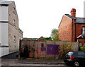
Development site, Lisburn Road/Tate's Avenue, Belfast (3)
The numbering in Ashley Avenue is not too easy to decipher but I take this to be the Ashley Avenue end of the site.
Image: © Albert Bridge
Taken: 31 Oct 2010
0.09 miles
10
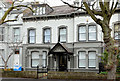
No 31 Ulsterville Avenue, Belfast
No 31 Ulsterville Avenue is a large double-fronted former house on the north eastern side of the street. Listed as HB26/28/035 B but without any further information. It seems to date from the 1860/70’s, is now occupied by a charity but had a spell, in the early/mid 20th century, as the residence of the minister of Donegall Road Presbyterian church.
Image: © Albert Bridge
Taken: 8 Dec 2013
0.09 miles