IMAGES TAKEN NEAR TO
Jubilee Road, BELFAST, BT9 7JL
Introduction
This page details the photographs taken nearby to Jubilee Road, BT9 7JL by members of the Geograph project.
The Geograph project started in 2005 with the aim of publishing, organising and preserving representative images for every square kilometre of Great Britain, Ireland and the Isle of Man.

There are currently over 7.5m images from over14,400 individuals and you can help contribute to the project by visiting https://www.geograph.org.uk
Image Map
Images are licensed for reuse under creativecommons.org/licenses/by-sa/2.0
Notes
- Clicking on the map will re-center to the selected point.
- The higher the marker number, the further away the image location is from the centre of the postcode.
Image Listing (202 Images Found)
Images are licensed for reuse under creativecommons.org/licenses/by-sa/2.0
Image
Details
Distance
1
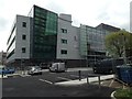
Cancer Research UK Centre, Belfast
It is located beside Belfast City Hospital
Image: © Kenneth Allen
Taken: 4 Jun 2015
0.03 miles
2
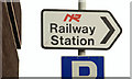
Railway direction sign, Belfast
A sign, on the Jubilee Road, pointing to the City Hospital station Image It shows the last of the Northern Ireland Railways logos (now replaced by the Translink variety). Railway stations are now “train stations” implying that they are stations on the train rather than stations (stopping places) on the railway. For something more recent (June 2013) see Image
Image: © Albert Bridge
Taken: 29 Nov 2009
0.06 miles
3
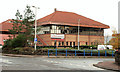
Blood Transfusion offices, Belfast
The headquarters of the NI Blood Transfusion Service, on the Jubilee Road, close to the City Hospital.
Image: © Albert Bridge
Taken: 29 Nov 2009
0.07 miles
4
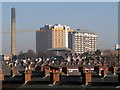
Belfast rooftops
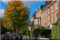
The rooftops of the close-knit terracing on the western side of the Lisburn Road in Belfast. Beyond is the towering Belfast City Hospital.
Image: © Rossographer
Taken: 13 Feb 2008
0.08 miles
5
Ulsterville Avenue, Belfast
Off the Lisburn Road, Ulsterville Avenue was once a very genteel place to live. Its proximity to Queen’s University has changed it from an “avenue” to a “street” of houses of multiple occupation. See also Image
Image: © Albert Bridge
Taken: 4 Oct 2007
0.08 miles
6
Dunluce Avenue, Belfast (1)
Dunluce Avenue runs from the Lisburn Road towards the Belfast – Dublin railway. Now mostly converted to flats and bedsits. This is the Lisburn Road end. See also Image
Image: © Albert Bridge
Taken: 1 Feb 2009
0.09 miles
7
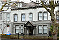
No 31 Ulsterville Avenue, Belfast
No 31 Ulsterville Avenue is a large double-fronted former house on the north eastern side of the street. Listed as HB26/28/035 B but without any further information. It seems to date from the 1860/70’s, is now occupied by a charity but had a spell, in the early/mid 20th century, as the residence of the minister of Donegall Road Presbyterian church.
Image: © Albert Bridge
Taken: 8 Dec 2013
0.10 miles
8
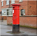
Pillar box, Belfast
An EVIIR pillar box (BT9 261) at Ulsterville Avenue.
Image: © Albert Bridge
Taken: 8 Dec 2013
0.10 miles
9
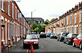
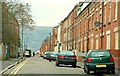
Coolfin Street, Belfast
An unredeveloped street, off the Donegall Road, still retaining its late 19th century terrace houses. The dark building (background) is the workhouse of 1841, now part of the City Hospital.
Image: © Albert Bridge
Taken: 24 Sep 2010
0.10 miles
10
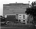
Queen's University Medical Biology Centre, Belfast
Medical Biology Centre of the Queen's University of Belfast, located on the Lisburn Road.
A rather mundane mix of modern buildings, it is located on the former site of the Deaf and Dumb Institution (built 1843-45 to a design by Charles Lanyon). The demolition was later described as "regrettable" by the university, and this decision was to become a catalyst for the formation of the Ulster Architectural Heritage Society.
Image: © Rossographer
Taken: 6 Aug 2008
0.11 miles