IMAGES TAKEN NEAR TO
Castlerobin Road, BELFAST, BT8 7DX
Introduction
This page details the photographs taken nearby to Castlerobin Road, BT8 7DX by members of the Geograph project.
The Geograph project started in 2005 with the aim of publishing, organising and preserving representative images for every square kilometre of Great Britain, Ireland and the Isle of Man.

There are currently over 7.5m images from over14,400 individuals and you can help contribute to the project by visiting https://www.geograph.org.uk
Image Map
Images are licensed for reuse under creativecommons.org/licenses/by-sa/2.0
Notes
- Clicking on the map will re-center to the selected point.
- The higher the marker number, the further away the image location is from the centre of the postcode.
Image Listing (6 Images Found)
Images are licensed for reuse under creativecommons.org/licenses/by-sa/2.0
Image
Details
Distance
1
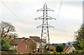
Pylons and power lines, Belvoir, Belfast
Pylons and power lines in the Belvoir estate. The one nearest the camera is behind the houses at Castlecoole Park. They are a continuation, (approximately) north east from Image and cross the Belvoir Road Image to here Image
Image: © Albert Bridge
Taken: 31 Dec 2012
0.20 miles
2
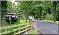
The entrance to Belvoir Forest, Belfast (August 2014)
The vehicle entrance to Belvoir Forest, off Belvoir Drive. There are also several pedestrian entrances from the Lagan towpath.
Image: © Albert Bridge
Taken: 8 Aug 2014
0.20 miles

4
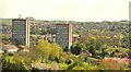
Belvoir Park flats, Belfast
The two high-rise blocks of the Belvoir Park estate seen from Terrace Hill above the Minnowburn Beeches. Continue to Image
Image: © Albert Bridge
Taken: 27 Apr 2009
0.23 miles
5

Lords and ladies, Belvoir Forest, Belfast (October 2014)
One of two small examples, of the lords and ladies plant, still surviving in mid-October.
Image: © Albert Bridge
Taken: 18 Oct 2014
0.25 miles
6
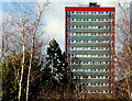
Belvoir Park flats, Belfast (2)
Another look at one of the two blocks seen in Image Architecturally a close relative of those at Seymour Hill Image I can’t confirm the exact date of building but it seems to have been circa 1959/62.
Image: © Albert Bridge
Taken: 8 Feb 2010
0.25 miles