IMAGES TAKEN NEAR TO
Church Road, BELFAST, BT8 7AN
Introduction
This page details the photographs taken nearby to Church Road, BT8 7AN by members of the Geograph project.
The Geograph project started in 2005 with the aim of publishing, organising and preserving representative images for every square kilometre of Great Britain, Ireland and the Isle of Man.

There are currently over 7.5m images from over14,400 individuals and you can help contribute to the project by visiting https://www.geograph.org.uk
Image Map
Images are licensed for reuse under creativecommons.org/licenses/by-sa/2.0
Notes
- Clicking on the map will re-center to the selected point.
- The higher the marker number, the further away the image location is from the centre of the postcode.
Image Listing (51 Images Found)
Images are licensed for reuse under creativecommons.org/licenses/by-sa/2.0
Image
Details
Distance
1
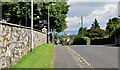
The Church Road, Newtownbreda, Belfast (August 2014)
A suburban road, bypassed by the Saintfield Road, which has the distinction of being stopped up at both ends (Image is behind me). Access to/from the Saintfield Road is by way of Upper Galwally (north) and Purdy’s Lane (south). This view is inward with the wall of Belvoir Park golf course on the left.
Image: © Albert Bridge
Taken: 6 Aug 2014
0.01 miles
2
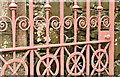
Cast-iron gate, Knockbreda (CoI) parish church, Belfast (April 2017)
A close look at part of one of the entrance gates to Knockbreda (CoI) parish church Image The official listing includes this description “footpath opening onto Church Road via flight of stone steps and pair of decorative cast-iron gates on tall square-plan stone piers with pyramidal capstones. Gates flanked by rubblestone quadrant walls”.
Image: © Albert Bridge
Taken: 27 Apr 2017
0.03 miles
3
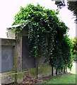
McAdam memorial, Knockbreda Cemetery, Belfast
The memorial to various members of the McAdam family, the headstone heavily obscured by ivy. The most celebrated member of the family buried here is Robert Shipboy McAdam (1808-95) who, in 1832 along with his brother James, established the Soho Engineering Foundry at Townsend Street, Belfast. Said to have spoken some 13 languages, he published a Gaelic Grammar and founded the Ulster Gaelic Society. McAdam was also the principal founder of the Ulster Journal of Archaeology in 1853 and a member of the Belfast Literary Society, the Belfast Natural History and Philosophical Society, the Linenhall Library and the Harmonic and Harp Societies. He lived in College Square East - see Image
Image: © Rossographer
Taken: 16 May 2008
0.03 miles
4
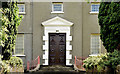
Knockbreda (Church of Ireland) parish church, Belfast (August 2014)
See Image in May 2008. The trees have grown sufficiently, over the last six years, so that an identical photograph is no longer possible. This is part of the front of the church, which, in this view, has the appearance of a rather grand Georgian house. This link http://www.knockbredaparish.org/about/history/ is to the official history. It’s worth recording that Knockbreda, now pure suburbia, was a rural area when the church was built.
Image: © Albert Bridge
Taken: 6 Aug 2014
0.04 miles
5
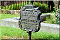
McKelvey burying ground, Knockbreda churchyard, Belfast
A cast-iron grave marker, similar to this one made by the Millfield Foundry Image, with the following inscription “THE FAMILY BURYING GROUND OF SAMUEL McKELVEY WOODSTOCK ROAD BELFAST 1894”.
Image: © Albert Bridge
Taken: 6 Aug 2014
0.04 miles
6
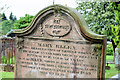
"Brown" headstone, Knockbreda churchyard, Belfast
A headstone with the inscription “IN MEMORY OF MARY ELLEN THE BELOVED WIFE OF GEORGE BROWN MARINER OF ANNAN, WHO DIED AT BELFAST 19TH MAY 1856. AGED 52 YEARS. ALSO OF MARY, WIDOW OF JOHN BROWN MARINER & MOTHER OF THE ABOVE NAMED GEORGE BROWN WHO DIED AT BELFAST 26TH MARCH 1859, AGED 69 YEARS.”
Image: © Albert Bridge
Taken: 6 Aug 2014
0.04 miles
7
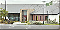
Clubhouse, Belvoir Park Golf Club, Belfast (April 2017)
The clubhouse at Belvoir Park Golf Club https://en.wikipedia.org/wiki/Belvoir_Park_Golf_Club seen from the Church Road Image
The course was built in 1927 on what had previously been part of the Deramore estate https://en.wikipedia.org/wiki/Baron_Deramore. For Geographing purposes it occupies a significant part this grid square http://www.geograph.org.uk/browse.php?p=467656&by=centi.
Image: © Albert Bridge
Taken: 27 Apr 2017
0.04 miles
8
![Knockbreda Parish Church, Belfast [detail]](https://s2.geograph.org.uk/photos/79/97/799730_7886ee05_120x120.jpg)
Knockbreda Parish Church, Belfast [detail]
Detail of the spire on Image
Image: © Rossographer
Taken: 12 May 2008
0.05 miles
9
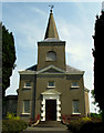
Knockbreda Parish Church, Belfast
Funded solely by the Dowager Viscountess Middleton and designed by the leading architect in Ireland of the time, Richard Castles (or Cassels), the church was consecrated in August 1737. The apsidal chancel was added by Thomas Drew in 1883 and the vestry by R.I. Caldwell CE in 1910. The parish graveyard contains many fine monuments, including late 18th Century mausoleums - see Image, Image and Image Many other wealthy or prominent Belfast citizens from the 18th and 19th centuries are also buried here. Alongside the old parish graveyard is the newer Knockbreda Cemetery, still in use today.
Image: © Rossographer
Taken: 12 May 2008
0.05 miles
10
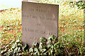
Hazley headstone, Knockbreda churchyard, Belfast
A simple slate grave marker with the inscription “THE FAMILY BURYING GROUND OF FRANCES HAZLEY BELFAST” (no dates).
Image: © Albert Bridge
Taken: 6 Aug 2014
0.05 miles