IMAGES TAKEN NEAR TO
Cairnshill Drive, BELFAST, BT8 6RT
Introduction
This page details the photographs taken nearby to Cairnshill Drive, BT8 6RT by members of the Geograph project.
The Geograph project started in 2005 with the aim of publishing, organising and preserving representative images for every square kilometre of Great Britain, Ireland and the Isle of Man.

There are currently over 7.5m images from over14,400 individuals and you can help contribute to the project by visiting https://www.geograph.org.uk
Image Map
Images are licensed for reuse under creativecommons.org/licenses/by-sa/2.0
Notes
- Clicking on the map will re-center to the selected point.
- The higher the marker number, the further away the image location is from the centre of the postcode.
Image Listing (8 Images Found)
Images are licensed for reuse under creativecommons.org/licenses/by-sa/2.0
Image
Details
Distance
1
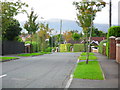
Pennington Park, Four Winds, Belfast
A mature street off the Cairnshill Road in the Four Winds suburb of Belfast.
Image: © Dean Molyneaux
Taken: 24 Sep 2009
0.18 miles
2
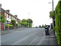
Alt-Min Avenue, Four Winds, Belfast
A cul-de-sac off Carnbrae Avenue.
Image: © Dean Molyneaux
Taken: 24 Sep 2009
0.23 miles
3
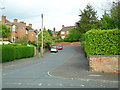
Beechill Park, Belfast
One of the many streets that sprung up here around the Four Winds in the late 1960s. Off the old Saintfield Road.
Image: © Dean Molyneaux
Taken: 24 Sep 2009
0.23 miles
4
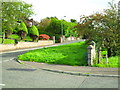
The old Saintfield Road at Beechill, Belfast
Replaced in the 1960s by much smoother road, the old Saintfield Road serves many houses and streets in the older part of the Four Winds area.
Image: © Dean Molyneaux
Taken: 24 Sep 2009
0.23 miles
5
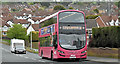
Bus, Cairnshill Road, Belfast (April 2017)
A Metro Wright-bodied Volvo (2384 SFZ 9384) running along the Cairnshill Road with a 7A Four Winds – Howard Street service.
Image: © Albert Bridge
Taken: 20 Apr 2017
0.23 miles
6
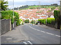
Cairnshill Road at Pennington Park, Belfast
The Cairnshill Road was widened and realigned in 1986 in order to meet the demands of the massive Fraser Homes development (nearly every house in this picture).
Image: © Dean Molyneaux
Taken: 24 Sep 2009
0.24 miles
7
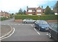
Entrance to Beechfield Park off Saintfield Road, Cairnshill
The grey car is on the Old Saintfield Road.
Image: © Eric Jones
Taken: 27 Apr 2012
0.24 miles
8
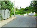
Commons Brae, Belfast
Once a steep cul-de-sac off the Saintfield Road, it now links onto Burnside Avenue.
Image: © Dean Molyneaux
Taken: 24 Sep 2009
0.24 miles