IMAGES TAKEN NEAR TO
College Heights, BELFAST, BT7 3LG
Introduction
This page details the photographs taken nearby to College Heights, BT7 3LG by members of the Geograph project.
The Geograph project started in 2005 with the aim of publishing, organising and preserving representative images for every square kilometre of Great Britain, Ireland and the Isle of Man.

There are currently over 7.5m images from over14,400 individuals and you can help contribute to the project by visiting https://www.geograph.org.uk
Image Map
Images are licensed for reuse under creativecommons.org/licenses/by-sa/2.0
Notes
- Clicking on the map will re-center to the selected point.
- The higher the marker number, the further away the image location is from the centre of the postcode.
Image Listing (49 Images Found)
Images are licensed for reuse under creativecommons.org/licenses/by-sa/2.0
Image
Details
Distance
1
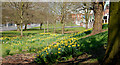
Daffodils, Belfast (2)
Clumps growing at the southern end of the Annadale Embankment.
Image: © Albert Bridge
Taken: 12 Apr 2010
0.14 miles
2
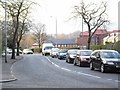
Traffic jam on Annadale Embankment, Belfast
This collossal queue stretched from the Ormeau Road, along Annadale Avenue - which here becomes Annadale Embankment as it curves down to the river - right back to the Governor's Bridge.
Image: © Dean Molyneaux
Taken: 10 Mar 2010
0.14 miles
3
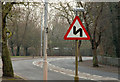
"Double bend", sign, Belfast
A double-bend sign for traffic heading outwards along the Annadale Embankment. The foreshortening caused by the long lens creates an illusion. The first bend really is to the left.
Image: © Albert Bridge
Taken: 26 Jan 2010
0.14 miles
4
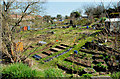
The Annadale allotments, Belfast
Beside of the Annadale Embankment and Annadale Avenue. One of four sites operated by Belfast City Council.
Image: © Albert Bridge
Taken: 12 Apr 2010
0.15 miles
5
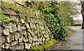
Drystone wall, Belfast
Drystone walls don’t have to be in hill country and look like Image This one, with not a trace of mortar (but plenty of soil), is beside this part of the Annadale Embankment Image
Image: © Albert Bridge
Taken: 8 Mar 2012
0.17 miles
6
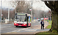
Holywood Exchange bus, Belfast
There is an hourly (off-peak) service (no 29) from Howard Street to the Holywood Exchange shopping centre. It runs via a devious route which includes Annadale, Mount Merrion, The Braniel, Dundonald, Stormont and the Old Holywood Road. This is the 11.40 on the Annadale Embankment. The journey is booked to take a staggering 71 minutes. Good value for those on a one-day ticket.
Image: © Albert Bridge
Taken: 26 Jan 2010
0.17 miles
7
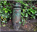
Old lamppost, Belfast
What looks like the stump of an old lamppost, at Annadale Avenue, beside Mornington.
Image: © Albert Bridge
Taken: 20 Jul 2011
0.17 miles
8
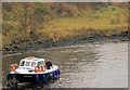
The "Sacha" at Stranmillis, Belfast (2)
See Image The inspection at the limit complete, the “Sacha” returns downstream close to the eastern (Annadale) side of the Lagan.
Image: © Albert Bridge
Taken: 26 Jan 2010
0.18 miles
9
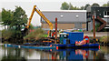
Dredging the River Lagan, Belfast - 2010/11 (25)
In the nine days since Image the operations have moved downstream to two places. This one (beside the Belfast Boat Club) on the south western side of the Lagan and one upstream of the King’s Bridge Image There is an empty barge alongside the pontoon ready to receive the next load. A few minutes before the photo a loaded barge had departed for Queen’s Quay Image
Image: © Albert Bridge
Taken: 14 Oct 2010
0.18 miles
10
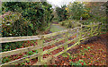
Lagan Lands East, Belfast (1)
A little-known piece of greenery, on the eastern side of the Lagan, at Annadale. This is the entrance from the Annadale Embankment. Continue to Image
Image: © Albert Bridge
Taken: 9 Nov 2009
0.19 miles