IMAGES TAKEN NEAR TO
Ormeau Road, BELFAST, BT7 2GB
Introduction
This page details the photographs taken nearby to Ormeau Road, BT7 2GB by members of the Geograph project.
The Geograph project started in 2005 with the aim of publishing, organising and preserving representative images for every square kilometre of Great Britain, Ireland and the Isle of Man.

There are currently over 7.5m images from over14,400 individuals and you can help contribute to the project by visiting https://www.geograph.org.uk
Image Map
Images are licensed for reuse under creativecommons.org/licenses/by-sa/2.0
Notes
- Clicking on the map will re-center to the selected point.
- The higher the marker number, the further away the image location is from the centre of the postcode.
Image Listing (156 Images Found)
Images are licensed for reuse under creativecommons.org/licenses/by-sa/2.0
Image
Details
Distance
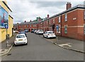
1
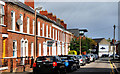
Deramore Street, Belfast
Late Victorian street running from Haywood Avenue to the Ormeau Road (background). The row on the left has its houses in three different styles.
Image: © Albert Bridge
Taken: 15 Sep 2010
0.01 miles
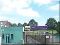
2
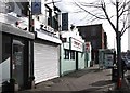
An Indian and Chinese Takeaways opposite Ballynafeigh Orange Hall
Image: © Eric Jones
Taken: 17 Feb 2015
0.01 miles
3
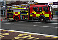
Fire appliance, Belfast
Northern Ireland Fire and Rescue Service appliance attending to a fire in a Chinese takeaway on the Ormeau Road in Belfast.
Image: © Rossographer
Taken: 4 Feb 2011
0.01 miles
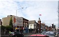
4
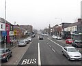
View SSE along Ormeau Road
This is the middle section of the Ormeau Road.
Image: © Eric Jones
Taken: 28 Mar 2017
0.02 miles
5
Ulidia Playing Fields
The Ulidia Playing Fields were formerly the Ormeau Cricket ground of the North of Ireland C.C. http://csnicc.com/north/index.asp In 1921 it hosted its first first class international game - that between Ireland and Wales. With a largely middle class Protestant membership the club based as it was in a working-class republican neighbourhood became a target for arsonists and decided in 2001 to withdraw from the area. The fields were then taken over by the Belfast City Council and converted into football pitches.
Image: © Eric Jones
Taken: 10 Jul 2015
0.02 miles
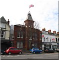
7
The Ballynafeigh section of Ormeau Road, Belfast
Ballynafeigh is a portion of the townland of Ballynafoy which lies immediately south of Ormeau Bridge. It is a culturally mixed area. The Union Flag flies over the Ballynafeigh Orange Hall.
Image: © Eric Jones
Taken: 17 Feb 2015
0.03 miles
8
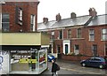
The entrance to Deramore Street from Ormeau Road
The shop is a Ferguson Flower Shop.
Image: © Eric Jones
Taken: 12 Mar 2011
0.03 miles
10
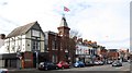
Block of buildings on Ormeau Road between Heyward Avenue and Deramore Road
The building sporting the large Union Flag is the Ballynafeigh Orange Hall.
Image: © Eric Jones
Taken: 17 Feb 2015
0.03 miles