IMAGES TAKEN NEAR TO
Fern Valley Close, CRAIGAVON, BT67 0TB
Introduction
This page details the photographs taken nearby to Fern Valley Close, BT67 0TB by members of the Geograph project.
The Geograph project started in 2005 with the aim of publishing, organising and preserving representative images for every square kilometre of Great Britain, Ireland and the Isle of Man.

There are currently over 7.5m images from over14,400 individuals and you can help contribute to the project by visiting https://www.geograph.org.uk
Image Map
Images are licensed for reuse under creativecommons.org/licenses/by-sa/2.0
Notes
- Clicking on the map will re-center to the selected point.
- The higher the marker number, the further away the image location is from the centre of the postcode.
Image Listing (8 Images Found)
Images are licensed for reuse under creativecommons.org/licenses/by-sa/2.0
Image
Details
Distance
1
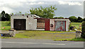
Former garage, Lurganville near Moira
See Image (August 2010). The same disused garage, on the Bridge Road opposite the Bottier Road, almost two years later.
Image: © Albert Bridge
Taken: 30 Jun 2012
0.13 miles
2

Junction of Bridge Road and Bottier Road, Lurganville
The main junction in the hamlet of Lurganville, which is behind the camera.
Townland of Lurganville.
Image: © Dean Molyneaux
Taken: 15 Aug 2010
0.15 miles
3

St. Colman's Church, Kilwarlin (Lurganville)
This is a brief history as recorded in a book ?Lisburn?s Rich Church Heritage? by John Kelly and sourced from http://www.lisburn.com/churches/Lisburn-churches/st-colmans-kilwarlin.html.
"St. Colman?s Church, Kilwarlin, was erected in 1812. The church was extensively renovated in 1967. Some of the earlier headstones in the adjoining cemetery relate to families from the parish of Aghalee, which was part of the Dromore Diocese even though it is located deep in the territory of the Diocese of Down and Connor. The adjoining parochial house was newly erected in 1964; Father Tom Mooney, P.P., was the first occupier. The present Parish Priest, the Very Rev. Brian Brown was installed here in November 2005."
The church is situated at the eastern end of the Bottier Road in the townland of Lurganville - approximately one mile southeast of Moira village.
Image: © Dean Molyneaux
Taken: 15 Aug 2010
0.15 miles
4
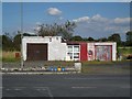
Disused garage at Lurganville
This was my first visit to the small hamlet of Lurganville so I've no recollection of this garage ever being open.
Image: © Dean Molyneaux
Taken: 15 Aug 2010
0.15 miles
5
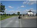
Bottier Road at St. Colman's Church, Lurganville
Looking towards the hamlet of Lurganville - a mile southeast of Moira. The row of houses on the right is Laganview Terrace.
This Bottier Road (one of two in the townland of Bottier) leads from Lurganville westwards to the Clarehill Road, just short of Moira village.
Image: © Dean Molyneaux
Taken: 15 Aug 2010
0.18 miles
6
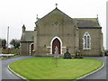
St. Colman's, Kilwarlin
Built in 1812 and extensively renovated in 1967. In the parish of Magheralin, it is in the Diocese of Dromore for historical reasons, despite being situated deep in the territory of the Diocese of Down & Connor.
Image: © Brian Shaw
Taken: 10 Jan 2006
0.19 miles
7
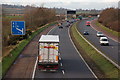
The M1 south east of Moira (1)
See Image This is the view toward the former from the bridge near Flatfield. The bridge carries the Bridge Road across the motorway. The one-mile advance sign for the Moira exit Image can be seen on the left.
Image: © Albert Bridge
Taken: 9 Jan 2007
0.19 miles
8
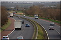
The M1 south east of Moira (2)
See Image This is the view towards Belfast from the same bridge. The monument on the horizon is in another square!!!! See Image
Image: © Albert Bridge
Taken: 9 Jan 2007
0.19 miles