IMAGES TAKEN NEAR TO
Helens Park, CRAIGAVON, BT67 0EN
Introduction
This page details the photographs taken nearby to Helens Park, BT67 0EN by members of the Geograph project.
The Geograph project started in 2005 with the aim of publishing, organising and preserving representative images for every square kilometre of Great Britain, Ireland and the Isle of Man.

There are currently over 7.5m images from over14,400 individuals and you can help contribute to the project by visiting https://www.geograph.org.uk
Image Map
Images are licensed for reuse under creativecommons.org/licenses/by-sa/2.0
Notes
- Clicking on the map will re-center to the selected point.
- The higher the marker number, the further away the image location is from the centre of the postcode.
Image Listing (33 Images Found)
Images are licensed for reuse under creativecommons.org/licenses/by-sa/2.0
Image
Details
Distance
1
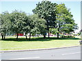
Aghalee village
On the Soldierstown Road
Image: © HENRY CLARK
Taken: 24 Jun 2009
0.05 miles
2
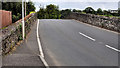
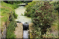
Canal bridge, Aghalee
See Image The canal originally continued, to Lough Neagh, under this hump-backed bridge on the Soldierstown Road. The towpath ends its journey, on the right, on the other (Lower Ballinderry) side of the hump.
Image: © Albert Bridge
Taken: 10 Jul 2011
0.06 miles
3
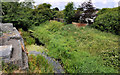
Disused Lagan canal. Aghalee (1)
See Image This is the view of the disused Lagan canal on the Lough Neagh side of the Aghalee bridge Image, where the towpath ends. Ideally the towpath would/could be restored to the loughshore but there are probably numerous obstacles including financial, land acquisition and the fact that it would involve Lisburn and Craigavon councils in a joint effort. Continue to Image
Image: © Albert Bridge
Taken: 10 Jul 2011
0.06 miles
4
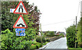
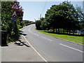
Road signs, Aghalee
“Road narrows on both sides” and “hump bridge”, signs on the Soldierstown Road, approaching this bridge Image The lower signs refer to National Cycle Network route no 2, including Moira via the towpath.
Image: © Albert Bridge
Taken: 12 May 2013
0.06 miles
5
Disused Lagan canal. Aghalee (2)
Image: © Albert Bridge
Taken: 10 Jul 2011
0.07 miles
6
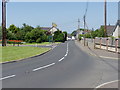
Soldierstown Road leaving Aghalee over the Canal Bridge
Image: © HENRY CLARK
Taken: 24 Jun 2009
0.07 miles
7
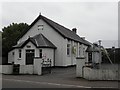
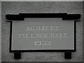
Aghalee Village Hall
Built in 1933, it is located along Lurgan Road
See close-up of plaque here Image]
Image: © Kenneth Allen
Taken: 9 Oct 2010
0.11 miles
9
Plaque, Aghalee Village Hall
It is located here Image]
Image: © Kenneth Allen
Taken: 9 Oct 2010
0.11 miles
10
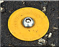
Survey mark, Aghalee
One of about a dozen such studs, made visible by the yellow plastic surround, in the footpath on the Soldierstown Road. Used by surveyors and working (I think) on the same principle as Image For another example see Image
Image: © Albert Bridge
Taken: 12 May 2013
0.11 miles