IMAGES TAKEN NEAR TO
Carbet Manor, CRAIGAVON, BT63 5AH
Introduction
This page details the photographs taken nearby to Carbet Manor, BT63 5AH by members of the Geograph project.
The Geograph project started in 2005 with the aim of publishing, organising and preserving representative images for every square kilometre of Great Britain, Ireland and the Isle of Man.

There are currently over 7.5m images from over14,400 individuals and you can help contribute to the project by visiting https://www.geograph.org.uk
Image Map
Images are licensed for reuse under creativecommons.org/licenses/by-sa/2.0
Notes
- Clicking on the map will re-center to the selected point.
- The higher the marker number, the further away the image location is from the centre of the postcode.
Image Listing (6 Images Found)
Images are licensed for reuse under creativecommons.org/licenses/by-sa/2.0
Image
Details
Distance
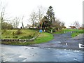
1
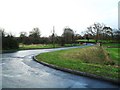
Carbet Road, Tamnificarbet
The Carbet Road originally ran from Ballynacor to Balteagh (two townlands to the north-east of Portadown). As part of the Craigavon New Town project in 1968 in which a lot of local farmland was vested, the western section of this road was swallowed up by what was to be the Craigavon Shopping Centre - leaving the Carbet Road to end at Kilvergan.
Townland of Tamnificarbet. Seen here at the junction with the Drumnagoon Road, which leads to Carn.
Image: © Dean Molyneaux
Taken: 22 Nov 2009
0.01 miles
2
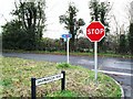
Signs at Tamnificarbet
At the junction of the Drumnagoon and Carbet Roads. National Cycle Network route 94 passes through the area as part a loop from Craigavon to Bannfoot.
Image: © Dean Molyneaux
Taken: 22 Nov 2009
0.04 miles
3
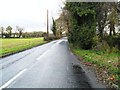
Drumnagoon Road, Tamnificarbet
Leads from the Carbet Road into the Carn Industrial Estate on the northeast edge of Portadown.
Image: © Dean Molyneaux
Taken: 22 Nov 2009
0.07 miles
4
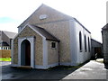
Ballinacor Methodist Church, Carbet Road.
Established in 1845.
Image: © P Flannagan
Taken: 16 Aug 2007
0.11 miles
5
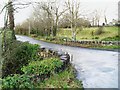
Kesh Bridge, Balteagh
This carries the Kilvergan Road over the Closet River in the townland of Balteagh.
Image: © Dean Molyneaux
Taken: 22 Nov 2009
0.22 miles
6
'The Craigavon Effect', Balteagh
What the fields between Lurgan and Portadown were like before the Craigavon New Town project (1968) has become largely forgotten.
The new town's mark remains evident here though as the Carbet Road is suddenly diverted onto the Kilvergan Road - in the townland of Balteagh.
In 1968, continuing straight would have brought you over the Balteagh Railway Bridge and onto the Lurgan to Portadown A3 road, roughly where the Craigavon Shopping Centre (Rushmere) stands today.
Image: © Dean Molyneaux
Taken: 22 Nov 2009
0.22 miles