IMAGES TAKEN NEAR TO
Cow Fair, ARMAGH, BT60 3UE
Introduction
This page details the photographs taken nearby to Cow Fair, BT60 3UE by members of the Geograph project.
The Geograph project started in 2005 with the aim of publishing, organising and preserving representative images for every square kilometre of Great Britain, Ireland and the Isle of Man.

There are currently over 7.5m images from over14,400 individuals and you can help contribute to the project by visiting https://www.geograph.org.uk
Image Map
Images are licensed for reuse under creativecommons.org/licenses/by-sa/2.0
Notes
- Clicking on the map will re-center to the selected point.
- The higher the marker number, the further away the image location is from the centre of the postcode.
Image Listing (80 Images Found)
Images are licensed for reuse under creativecommons.org/licenses/by-sa/2.0
Image
Details
Distance
1
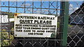
Old Southern Railway Sign
Very old Southern Railway sign on the gates to "The Furniture Restorer" on Tassagh Road, Keady. The railway at Keady opened in 1909 and closed in 1957.
Image: © Sean Davis
Taken: 4 Mar 2020
0.04 miles
2
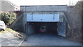
Keady Tunnel
The Keady Tunnel was built c1909 to take the proposed Ulster and Connacht Light Railway. The railway was to join Newry to Clifden. The route was to go through Bessbrook, Keady, Tynan, Maguiresbridge, Drumod, Roscommon, Tuam and Galway. However, the railway was not built and the tunnel is now used as a bus garage.
Image: © Sean Davis
Taken: 4 Mar 2020
0.05 miles
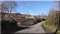
3
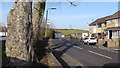
Tassagh Road
Looking along Tassagh Road as it exits Keady. Taken from the bottom of "The Black Pad".
Image: © Sean Davis
Taken: 22 Mar 2020
0.05 miles
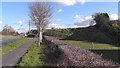
4
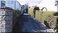
The Black Path
Looking up the black path from Tassagh Road. Known locally as "the black pad", this is a short cut between Tassagh Road and Armagh Road in Keady.
Image: © Sean Davis
Taken: 1 Mar 2020
0.07 miles
5
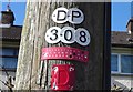
Telephone Pole Maintenance Record
Recently maintained telephone pole on Tassagh Road, Keady. Recorded as last done in December 2019 and the work done was "H" - whatever that is?
Image: © Sean Davis
Taken: 4 Mar 2020
0.07 miles
6
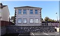
Tassagh Road Medical Centre
The medical centre on the Tassagh Road in Keady.
Image: © Sean Davis
Taken: 1 Mar 2020
0.07 miles
7
Keady Sewage Works
The Keady Sewage Works from Glen Road.
Image: © Sean Davis
Taken: 4 Mar 2020
0.07 miles
8
Remains of Old Railway Embankment
Looking west along Tassagh Road at the remains of the old railway embankment. This was just a short distance west of the old Keady Railway Station which closed in 1957. See https://en.wikipedia.org/wiki/Keady_railway_station
Image: © Sean Davis
Taken: 4 Mar 2020
0.07 miles
9
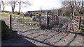
Lots of Gates on Glen Road
The farmer must have had lots of fun working out the layout of all these gates on Glen Road in Keady.
Image: © Sean Davis
Taken: 4 Mar 2020
0.07 miles
10
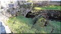
Bridge over River Clea
Old, private access bridge, over River Clea, to bungalow on Glen Road, Keady.
Image: © Sean Davis
Taken: 4 Mar 2020
0.08 miles