IMAGES TAKEN NEAR TO
Fergort Road, ARMAGH, BT60 3DN
Introduction
This page details the photographs taken nearby to Fergort Road, BT60 3DN by members of the Geograph project.
The Geograph project started in 2005 with the aim of publishing, organising and preserving representative images for every square kilometre of Great Britain, Ireland and the Isle of Man.

There are currently over 7.5m images from over14,400 individuals and you can help contribute to the project by visiting https://www.geograph.org.uk
Image Map
Images are licensed for reuse under creativecommons.org/licenses/by-sa/2.0
Notes
- Clicking on the map will re-center to the selected point.
- The higher the marker number, the further away the image location is from the centre of the postcode.
Image Listing (12 Images Found)
Images are licensed for reuse under creativecommons.org/licenses/by-sa/2.0
Image
Details
Distance
1
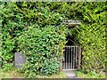
Entrance to St Mochua's Well (St Malachy)
Image: © Kenneth Allen
Taken: 14 Sep 2012
0.03 miles
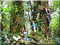
2

Interior of St Malachy's Well
I noticed round the inside that there were cloths tied to branches of trees
and notices not to leave rags Image]
Pictured here Image]
Image: © Kenneth Allen
Taken: 14 Sep 2012
0.04 miles
3
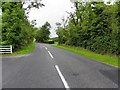
B3 Fergort Road, Derrynoose
Heading north-west
Image: © Kenneth Allen
Taken: 14 Sep 2012
0.04 miles
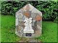
4
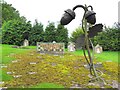
Religious crosses and figures, St Malachy's Well
Pictured here Image]
Image: © Kenneth Allen
Taken: 14 Sep 2012
0.04 miles
5

"Do not leave rags" notices, St Malachy's Well
There is a similar situation at Dromore, in County Tyrone, on a smaller scale, where the Eye Well is located outside the town, in which cloths are left beside the well, which is reputed to have healing properties Image]
Pictured here Image]
Image: © Kenneth Allen
Taken: 14 Sep 2012
0.05 miles
6
Station of the Cross (detail)
Pictured here Image]
Image: © Kenneth Allen
Taken: 14 Sep 2012
0.07 miles
7
Derrynoose Townlands (Doire N?is)
The townlands are located on the ground in front of the tiled display
Note the stations of the cross, each one featuring a local family Image]
More at http://en.wikipedia.org/wiki/Derrynoose
Image: © Kenneth Allen
Taken: 14 Sep 2012
0.08 miles
8
Stations of the cross, Derrynoose
Image: © Kenneth Allen
Taken: 14 Sep 2012
0.08 miles
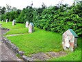
9
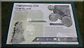
Information Board at Derrynoose Old Graveyard
This old graveyard is in Listarkelt Ancient Rath at Derrynoose, County Armagh. It was the site of Derrynoose Monastery, founded in the 6th century by St Mochua. There are still the ruins of a 17th century church. It sits on a hill above the B3 (Fergort Road). Across the B3 is St Machua's Holy Well. It is claimed the "Derrynoose Cursing Stone" is buried here. The stone is said to have brought bad luck. Also, see video I have done at https://www.youtube.com/watch?v=VgebaD0Ik5Q&t=16s where my daughter reads the information board.
Image: © Sean Davis
Taken: 8 Jul 2021
0.10 miles
10
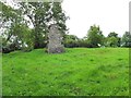
Remains of the old chapel, Derrynoose
Only one small section of the church still stands
Image: © Kenneth Allen
Taken: 14 Sep 2012
0.10 miles