Information Board at Derrynoose Old Graveyard
Introduction
The photograph on this page of Information Board at Derrynoose Old Graveyard by Sean Davis as part of the Geograph project.
The Geograph project started in 2005 with the aim of publishing, organising and preserving representative images for every square kilometre of Great Britain, Ireland and the Isle of Man.

There are currently over 7.5m images from over 14,400 individuals and you can help contribute to the project by visiting https://www.geograph.org.uk
Information Board at Derrynoose Old Graveyard
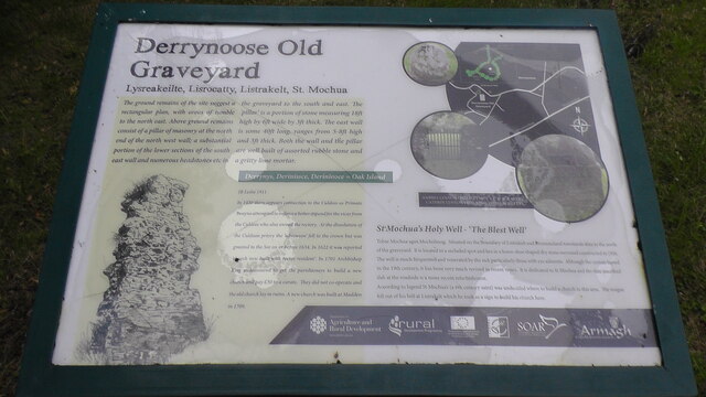
Image: © Sean Davis Taken: 8 Jul 2021
This old graveyard is in Listarkelt Ancient Rath at Derrynoose, County Armagh. It was the site of Derrynoose Monastery, founded in the 6th century by St Mochua. There are still the ruins of a 17th century church. It sits on a hill above the B3 (Fergort Road). Across the B3 is St Machua's Holy Well. It is claimed the "Derrynoose Cursing Stone" is buried here. The stone is said to have brought bad luck. Also, see video I have done at https://www.youtube.com/watch?v=VgebaD0Ik5Q&t=16s where my daughter reads the information board.
Images are licensed for reuse under creativecommons.org/licenses/by-sa/2.0
Image Location
Latitude
54.232577
Longitude
-6.784207