IMAGES TAKEN NEAR TO
Rosepark Central, BELFAST, BT5 7RN
Introduction
This page details the photographs taken nearby to Rosepark Central, BT5 7RN by members of the Geograph project.
The Geograph project started in 2005 with the aim of publishing, organising and preserving representative images for every square kilometre of Great Britain, Ireland and the Isle of Man.

There are currently over 7.5m images from over14,400 individuals and you can help contribute to the project by visiting https://www.geograph.org.uk
Image Map
Images are licensed for reuse under creativecommons.org/licenses/by-sa/2.0
Notes
- Clicking on the map will re-center to the selected point.
- The higher the marker number, the further away the image location is from the centre of the postcode.
Image Listing (55 Images Found)
Images are licensed for reuse under creativecommons.org/licenses/by-sa/2.0
Image
Details
Distance
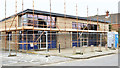
1
Rosepark House, Belfast (June 2016)
The prefabricated part of the building (right) has been removed.
Image: © Albert Bridge
Taken: 22 Jun 2016
0.10 miles
2
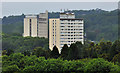
Carnet House, Belfast (4)
The multi-storey flats Carnet House (right) http://www.geograph.org.uk/search.php?i=32588074 and the Government offices Dundonald House Image, on the Upper Newtownards Road, seen from a height on the Ballyhanwood Road Image
Image: © Albert Bridge
Taken: 26 Jun 2012
0.10 miles
3
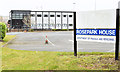
Rosepark House, Belfast - February 2015(2)
See Image The building is currently occupied by part of the Department of Finance and Personnel – soon to be re-named “Department of Finance”.
Image: © Albert Bridge
Taken: 28 Feb 2015
0.10 miles
4
Rosepark House, Belfast - February 2015(1)
A Government building, commonly called “Rosepark”, on the Upper Newtownards Road, built (I think) in the late 1960’s or early 1970’s, on what might have been the site of Dundonald telephone exchange. Originally in the form of a short-term building it was (much) later modernised to its present form. The name “Rosepark” comes from “Rose Park” a house (shown, on an old 25” map on the OSI website http://www.osi.ie/Home.aspx , approximately on the site of the present Dundonald House Image, on the other side of the road) owned by one of the Cleland family Image and Image See also Image Continue to Image
Image: © Albert Bridge
Taken: 28 Feb 2015
0.10 miles
5
Nos 697-699 Upper Newtownards Road, Belfast (February 2015)
The former First Trust Bank is now being converted as described in the shared description (below).
Image: © Albert Bridge
Taken: 28 Feb 2015
0.11 miles
6
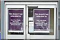
Former First Trust Bank (Stormont branch), Belfast - November 2014(2)
The closure notice on the front door.
Image: © Albert Bridge
Taken: 26 Nov 2014
0.11 miles
7
Former First Trust Bank (Stormont branch), Belfast - November 2014(1)
The former bank, now awaiting conversion to an alternative use – see the shared description (below).
Image: © Albert Bridge
Taken: 26 Nov 2014
0.11 miles
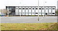
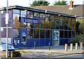
8
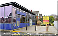
Former First Trust Bank (Stormont branch), Belfast
See Image (November 2013). The branch duly closed as anticipated and is now offered for sale. The agent’s website simply describes the property and makes no reference to the suitability of the site for housing. This photograph appears as a matter of record only. I am not involved in the sale of the premises.
Image: © Albert Bridge
Taken: 14 Feb 2014
0.11 miles
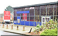
9
First Trust Bank (Stormont Branch), Belfast
The Stormont Branch of the First Trust Bank (697-703 Upper Newtownards Road) which is due to close with business transferring to Ballyhackamore Image It was originally a branch of the Allied Irish Bank (before the acquisition of the TSB operations in NI). There was also a sub branch, in the Parliament Buildings gate lodge, at Massey Avenue. Image (February 2014) shows the premises after closure.
Image: © Albert Bridge
Taken: 1 Nov 2013
0.11 miles
10
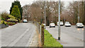
The Upper Newtownards Road, Rosepark, Belfast
The original line (on the inward side of Rosepark) of the Upper Newtownards Road which still serves local housing. The four-lane replacement (1960’s - I think) is on the right.
Image: © Albert Bridge
Taken: 14 Feb 2014
0.12 miles