IMAGES TAKEN NEAR TO
Kings Park, BELFAST, BT5 6PT
Introduction
This page details the photographs taken nearby to Kings Park, BT5 6PT by members of the Geograph project.
The Geograph project started in 2005 with the aim of publishing, organising and preserving representative images for every square kilometre of Great Britain, Ireland and the Isle of Man.

There are currently over 7.5m images from over14,400 individuals and you can help contribute to the project by visiting https://www.geograph.org.uk
Image Map
Images are licensed for reuse under creativecommons.org/licenses/by-sa/2.0
Notes
- Clicking on the map will re-center to the selected point.
- The higher the marker number, the further away the image location is from the centre of the postcode.
Image Listing (71 Images Found)
Images are licensed for reuse under creativecommons.org/licenses/by-sa/2.0
Image
Details
Distance
1
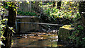
The Knock River, Belfast (5)
See Image The Knock River, looking upstream, seen from beside this footbridge Image Continue to Image
Image: © Albert Bridge
Taken: 8 Apr 2011
0.06 miles
2
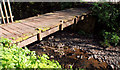
Footbridge, Belfast
A footbridge, across the Knock River, behind Cherryvalley.
Image: © Albert Bridge
Taken: 8 Apr 2011
0.06 miles
3
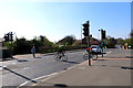
Comber Greenway
The cycle and pedestrian crossing, of the type named Puffin crossings, on the Kings Road. The railway line at this point went through a tunnel under the road and I remember back about 1954 standing on the bridge, just to the right of the cyclists position, watching the lifting of the track below. The tunnel has long since been blocked off.
Image: © Robert Ashby
Taken: 22 Apr 2015
0.07 miles
4
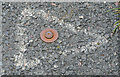
Survey mark, Knock, Belfast
This one, indicated by a painted triangle, is on the Comber Greenway close to Barnett’s Road.
Image: © Albert Bridge
Taken: 22 May 2013
0.07 miles
5
The Knock River, Belfast - April 2014(4)
Verdant spring greens on show, along the banks of the Knock River, upstream of this footbridge Image, close to Cherryvalley. This stretch of the river does not seem to be included in the Connswater Greenway scheme.
Image: © Albert Bridge
Taken: 25 Apr 2014
0.08 miles
6
Former Knock station, Belfast (2013)
The down platform remains but, in just over five years since this photograph Image (March 2008), it has become almost entirely hidden by vegetation. For the record it’s on the left when entering the Comber Greenway, at the King’s Road, going towards Dundonald.
Image: © Albert Bridge
Taken: 22 May 2013
0.08 miles
7
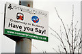
Comber Greenway sign, Belfast (2)
The proposal to convert the Comber Greenway (originally the Belfast and County Down Railway to Comber, Donaghadee, Downpatrick and Newcastle) has not been formally abandoned. This sign is at the King’s Road entrance. The spelling might be deliberate.
Image: © Albert Bridge
Taken: 18 Jan 2010
0.08 miles
8
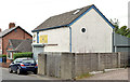
Former "car clinic", Belfast
Vacant premises, on Barnett’s Road, formerly occupied by a “car clinic”.
Image: © Albert Bridge
Taken: 29 Aug 2013
0.09 miles
9
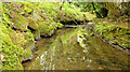
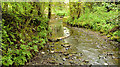
The Knock River, Belfast - April 2014(5)
The mossy banks of the Knock River, downstream of this footbridge Image, close to Cherryvalley. This stretch of the river does not seem to be included in the Connswater Greenway scheme.
Image: © Albert Bridge
Taken: 25 Apr 2014
0.09 miles
10
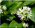
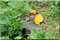
Wild garlic, Cherryvalley, Belfast (April 2014)
Wild garlic http://www.habitas.org.uk/flora/species.asp?item=2205 growing under the trees, on the south bank of the Knock River, at Cherryvalley - left in Image
Image: © Albert Bridge
Taken: 25 Apr 2014
0.09 miles