IMAGES TAKEN NEAR TO
Kensington Park, BELFAST, BT5 6NR
Introduction
This page details the photographs taken nearby to Kensington Park, BT5 6NR by members of the Geograph project.
The Geograph project started in 2005 with the aim of publishing, organising and preserving representative images for every square kilometre of Great Britain, Ireland and the Isle of Man.

There are currently over 7.5m images from over14,400 individuals and you can help contribute to the project by visiting https://www.geograph.org.uk
Image Map
Images are licensed for reuse under creativecommons.org/licenses/by-sa/2.0
Notes
- Clicking on the map will re-center to the selected point.
- The higher the marker number, the further away the image location is from the centre of the postcode.
Image Listing (14 Images Found)
Images are licensed for reuse under creativecommons.org/licenses/by-sa/2.0
Image
Details
Distance
1
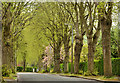
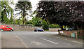
Cherryvalley Park, Belfast
Cherryvalley Park, a tree-lined street, standard in this part of Belfast, dates from the early 20th century. The 1907 street directory shows it almost fully developed with some houses still under construction at the Cherryvalley end. This view is towards the Kensington Road.
Image: © Albert Bridge
Taken: 25 Apr 2014
0.17 miles
2
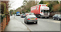
The Knock Road, Belfast (2)
Image: © Albert Bridge
Taken: 18 Jan 2010
0.20 miles
3
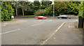
The Knock Road, Belfast (14)
The Knock Road at Knockcastle Park.
Image: © Albert Bridge
Taken: 15 Aug 2011
0.20 miles
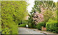
4
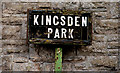
Kingsden Park sign, Belfast
Tiled sign, with the old postal district number painted on the post, at the Knock Road end of Kingsden Park.
Image: © Albert Bridge
Taken: 1 Apr 2011
0.21 miles
5
The Knock Road, Belfast (15)
The Knock Road at Knockvale Park.
Image: © Albert Bridge
Taken: 15 Aug 2011
0.21 miles
6
Cherryvalley, Belfast
Cherryvalley runs from the Knock Road (some distance behind me) to the Gilnahirk Road. The 1901 street directory shows that some houses had been built and occupied but others were still under construction.
Image: © Albert Bridge
Taken: 25 Apr 2014
0.21 miles
7
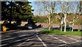
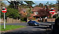
The Knock Road, Belfast (13)
The Knock Road at the Kensington Road – the Knock crossroads is to the right. Note: part of this photograph has been altered in the interest of security.
Image: © Albert Bridge
Taken: 8 Apr 2011
0.22 miles
8
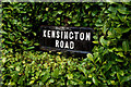
Kensington Road sign, Belfast
Traditional tiled sign, surrounded by a well-trimmed hedge, at the Knock Road end of Kensington Road.
Image: © Albert Bridge
Taken: 1 Apr 2011
0.22 miles
9
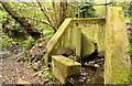
Drain, Knock River, Belfast (April 2014)
A drain (dry today), shortly after emerging from a culvert under Cherryvalley Image, at this stretch of the Knock River Image
Image: © Albert Bridge
Taken: 25 Apr 2014
0.22 miles
10
The Knock Road, Belfast (12)
The Knock Road at the Kensington Road – the Knock crossroads is to the right.
Image: © Albert Bridge
Taken: 8 Apr 2011
0.22 miles